Elias Baeck (1679 – 1747)
was a German painter, cartographer and engraver from Augsburg. He studied in Rome, then in Laybach/Ljubljana but finally returned to Augsburg. He painted and engraved portraits and landscapes but his chief work was the „Atlas Geographicus: oder Accurate Vorstellung der gantzen Welt“, published in Augsburg about 1720, in which he used mainly the maps of the famous French geographer and mapmaker Alexis Hubert Jaillot. His engravings are sometimes signed „E.B.a.H.“, standing for „Elias Baeck, alias Heldenmuth“ (Heroic).
Map details
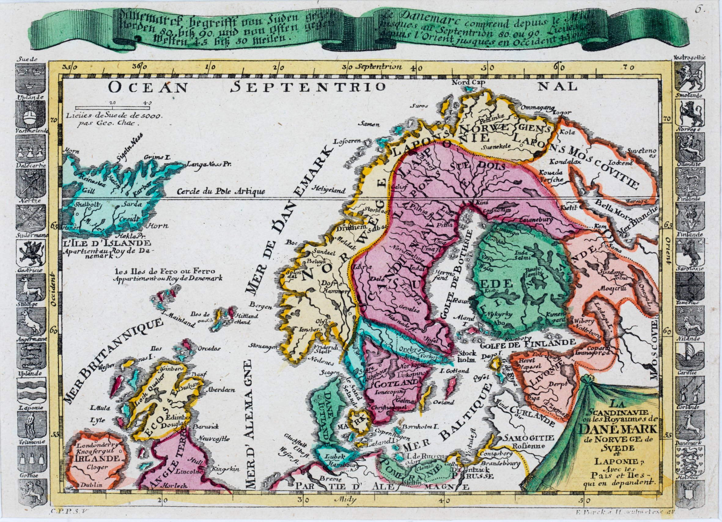
This very rare map was published in the „Atlas Geographicus“ and is signed with „E.B.a.H.“ underneath the map. It is decorated with an unusually shaped title cartouche in the lower right corner. „L‘Ile D‘Islande“ is drawn to scale in the upper left corner, together with the notice underneath: „Apertient au Roy de Danemark“ (Property of the King of Denmark). In the North Atlantic two distance scales are depicted. Ornamental embles of countries and regions are flanking the map.
The map covers Scandinavia, most of Iceland, the Faroe, Shetland and Orkney Islands, nearly all of Ireland, Scotland, half of England, the Baltic region, Prussia („Prusse“), „Pomeranie“ and the northern part of Germany („Partie d‘Allemagne“). „Moscovie“ is written vertical at the right hand side of the map.
Along the coastline of Iceland and also in the interior there are only a few place names, amongst them the bishoprics Skalholt and Holar („Halon“) and Hekla („M. Hel“). A main error is the positioning of the Arctic Circle („Cercle du Pole Artique“) which is placed in the center of Iceland.
In the „Schulte Collection“ there are four maps (No. 100, 111, 144 and 152) which look quite similar but mainly languages, frame decorations and publication years differ.
This map of Elias Baeck (No. 152) is in French language as the one of Danielle de Feuille (No. 144); the maps of Claude Buffier (No. 111) and the anonymous map (No. 100) are in Italian.
Three maps are flanked with coats of arms but these are omitted in the map of Claude Buffier (No. 111). Additionally Baeck‘s map (No. 152) is embellished by a long serpentine strap with German and French text headlining the map. These variations lead to slightly different sizes of the maps.
The map of Daniel de Feuille (No. 144) is the earliest map (1702) of those four; this map (No. 152) and the anonymous map (No. 100) have both been published around 1720 and the youngest map is the one by Claude Buffier (No. 111) of 1790.


