
Girolamo Ruscelli (1504 – 1566)
born in Viterbo, Tuscany was an Italian polymath, humanist and cartographer active in Venice during the early 16th century. He was not only a prominent writer on most varied subjects and a publisher but also an alchemist, mathematician, physician, writing pseudonymously as Alessio Piemontese. In his immensely popular book of alchemy „De Secreti Del Alessio Piemontese“ he described recipes for alchemical compounds, cosmetics, dyes, and medicines. It was reprinted for over two centuries and translated into numerous languages (French, English, German, Latin, Dutch, Spanish, Polish, Danish).
In 1561 Ruscelli issued an enlarged version of Giacomo Gastaldi‘s 1548 edition of Ptolemy‘s „Geographia“ (No. 70), published as „La Geografia di Claudio Tolomeo Alessandrino“ by Valgrisi. It is included newly engraved copperplates by Giulio and Livio Sanuti which were based generally on those of Gastaldi. Ruscelli‘s work was reprinted frequently throughout the rest of the century. The editions of 1562, in Latin, and of 1564, both in Italian and Latin, used the same copperplates. The next version, printed in 1574 in Italian, had a few newly engraved plates and was reprinted with some revisions in 1598 and 1599.
Ruscelli‘s and Gastaldi‘s maps, engraved in copper, marked a turning point in the history of cartography as afterwards, the majority of cartographic works used this medium. As copper is a harder material than wood it gave the engraver the ability to render more detail.
Map details
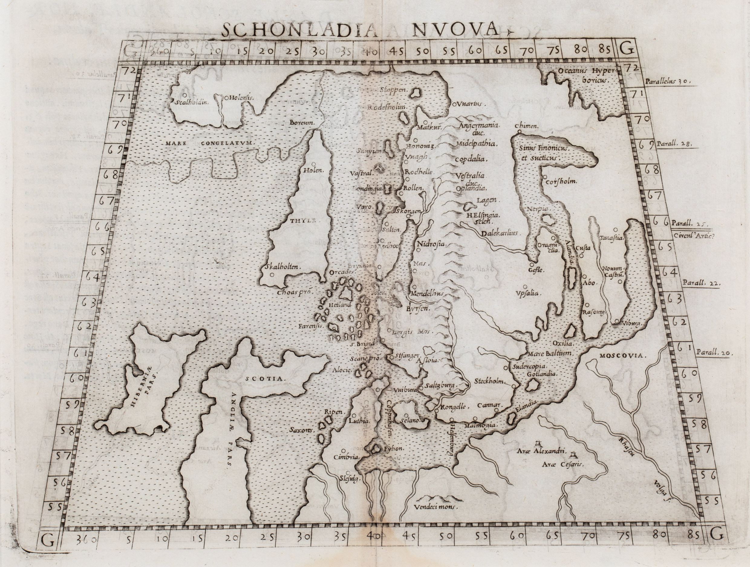
Scarce first state of the Ruscelli’s map, one of the earliest obtainable maps of Scandinavia, designed after the much rarer 1548 Gastaldi miniature map (No. 70). It was published in Ptolemy‘s „Geography“.
The title is placed on top of the map. Scandinavia is depicted in a trapezoidal projection. It also includes the Baltic region, the western part of Russia, Poland, the northern part of Germany, Ireland, Scotland and the northern part of England and stretches into the North Atlantic until Iceland and Greenland north of „Mare Congelatum“ (frozen sea).
There are some peculiarities in the depiction. Norway and Greenland are separated by a narrow strait but they seem to be connected by a land bridge. There is a group of three small islands in a strange geographical setting: the Orkney Islands („Orchades“) in the North, the Shetland Islands („Hetland“) in the South and the Faroe Islands („Farensis“) in the West.
Iceland is completely out of shape and bears the name „Thyle“ which refers to „Thule“, the legendary island described by the Greek Pytheas in the 4th century BC. In the interior there are only two place-names: the bishoprics „Skalholten“ (Skalholt) and „Holensis“ (Holar) without church symbols.
The main difference to the Gastaldi map (No. 70) is as follows. Gastaldi has written „Islandia“ and the names of the two bishoprics Skalholt and Holar not only in Iceland but also in Greenland. On this map Ruscelli has corrected this mistake by removing „Islandia“ from Greenland but also removed it from Iceland. So „Islandia“ is now completely missing.
Strangely enough, Ruscelli still uses the names of the two bishoprics, only written differently: in Iceland „Skalholten“ and „Holen“, in Greenland „Scalholdin“ and „Holensis“.