Lorenz Fries (c 1490 – 1531)
Lorenz Fries was a German physician, astrologer and cartographic editor, based in Strasbourg. Nothing is known about his youth and early schooling. His university education on philosophy and medicine has been acquired at several universities (Vienna, Montpellier, Piacenza, Padua) but it is not known from which he obtained a Doctor of Arts degree. He practiced medicine first in Selestat near Strasbourg, later in Colmar from 1514 to 1518 and wrote several medical works, including a trendy book titled „Spiegel der Artzny“ (Mirror of Medicine) with seven editions up to 1546. In 1519 Fries moved to Strasbourg and stayed there until 1525 when he decided to surrender his citizenship and relocated to Trier. In 1528 he moved to Basel and afterwards to Metz where he most likely died.
During his stay in Strasbourg Fries developed a relationship with the famous cartographer Martin Waldseemüller and the printer and publisher Johann Grüninger. From roughly 1520 to 1525 Fries worked closely with Grüninger as the geographic editor of various maps and atlases based upon the work of Waldseemüller. His first venture into mapmaking was in 1520 when he executed a reduction of Waldseemüller‘s wall-map of the world published in 1507. Around this time he also began working on Grüninger‘s reissue of Waldseemüller‘s 1513 edition of Claudius Ptolemy‘s, „Geographie Opus Novissima“ which was published by Johann Koberger in 1522.
In 1525, an improved edition was issued with a re-edit of the text by Willibald Pirkheimer, a Nuremberg humanist. After Grüninger‘s death in 1531, the business was continued by his son Christoph who seems to have sold the Ptolemy materials to two Lyon publishers, the brothers Melchius and Gaspar Trechsel who published a joint edition in 1535 before Gaspar did one of his own in 1541.
Editor of these editions was Michael Villanovus (Servetus). In 1553 he was tried for heresy. One of the allegations was that he had written a statement on the verso of the map of the Holy Land describing it as primarily infertile. Though the idea originated in Fries‘ edition of 1522 Servetus was burned at the stake, and at Calvin‘s orders, many copies of Servetus‘s books followed him into the flames.
Map details
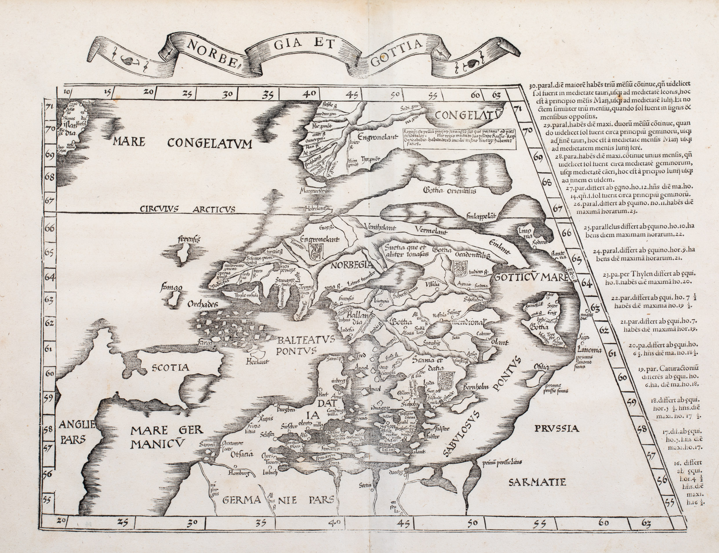
Fries‘ map is one of the earliest maps to focus on the northern parts of Europe, including Iceland and Greenland.
First published in Strasburg by Johann Grüninger in 1522, the Fries‘s map is based
upon the map in Martin Waldmüller‘s 1513 edition of the „Geographie Opus Novissima“ which is drawn on a Ptolemaic trapezoidal projection – but with changes, mainly of the shape which on the left-hand side now is nearly vertical. The text on the right edge describes the lengthening hours of daylight as a traveller moves north.
This rare woodcut map comes from the 7th edition of Ptolemy‘s „Geographia“, the
atlas „Geographicae enarationis libri octo Ex Billibaldi Pirckeymheri tralatione, fed ad Graeca & prisca exemplaria …“ published in Lyon after Lorenz Fries by Melchior & Gaspar Trechsel in 1535.
The title of the map „Norbegia et Gottia“ which is the same in all editions since 1522
is written on a banderole above it. „Norbegia“ stands for Norway, „Gottia“( Gothia) for Götaland, Schweden.
The map shows Scandinavia, the Baltic Sea, Prussia, „Sarmatia“ (?) and the northern part of Germany („Germanie Pars“), the eastern part of England („Anglie Pars“), Scotland („Scotia“), the Faroe Islands („ferensis“), a group of three small islands in a strange geographical setting: the Orkney Islands („Orchades“) in the North, the Shetland Islands („Herlant“) in the South and „faxas“ (?) in the West and a single island named „Famao“ (?).
Near the Norwegian coast is an island named „ThyleInsula“ which refers to the legendary island „Thule“ described by the Greek Pytheas in the 4th century BC.
Iceland („Islandia“) appears at the extreme upper left, erroneously situated north of the Arctic Circle („Circulus Arcticus“). Iceland is depicted as a long thin island with some (unrecognizable) names and no symbols.
There is frozen water („Mare Congelatum“) between Iceland and Greenland („Engronelant“) which is separated by a narrow isthmus from Scandinavia but in the east seems to be connected to the European landmass.
A text block describes Greenland as „Very abundant in precious furs, which are brought to Western ports. This region, having overthrown its own leader, is subject to the Russian ruler. The savage inhabitants are similar in countenance to the Samoyeds (from Latin)“.
In Scandinavia there are lots of place-names to be seen. Recognizable are only a few, eg „Asto“ stands for Oslo, „Begensis“ for Bergen, „Nodrosia“ for Nidaros=Trondheim.


