
Sebastian Münster (1488 – 1552)
born in Ingelheim, near Mainz, was a German cartographer, cosmographer and Professor of Hebrew. As a young man, he joined the Franciscan order in which he became a priest and then studied geography at the University of Tübingen. In 1518 he moved to Basel where he started to publish a Hebrew Grammar and three years later he moved again, to Heidelberg where he continued to publish Hebrew texts. After converting to Protestantism in 1529, he took over the chair of Hebrew at the University of Basel where he edited his main Hebrew work, a two-volume Old Testament, accompanied by a Latin translation. He also published a book on the basics of geometry „Rudimenta Mathematica“.
In 1525 Sebastian Münster published his first known map, a map of Germany, and in 1535 he released a map of Europe „Mappae Europae“. In 1540 he published „Geographia Universalis vetus et nova … Claudii Ptolemai Alexandrini …“ , an updated version of Ptolemy’s „Geographia“. In addition Münster added 21 „modern“ maps. One of Münster‘s innovations was to include one map for each continent, a concept that would influence Abraham Ortelius and other early mapmakers. The „Geographia“ was reprinted in 1542, 1545 and 1552.
Sebastian Münster is best known by his work „Cosmographia universalis“, first published in 1544 with 24 double-paged maps; it was one of the greatest geographical and historical works and most popular books of the 16th century, until the advent of Ortelius‘ „Theatrum“. This earliest German-language description of the world passed through numerous editions in different languages including Latin, French, Italian, English and Czech until 1628, long after his death. More than a half of all editions was in German language.
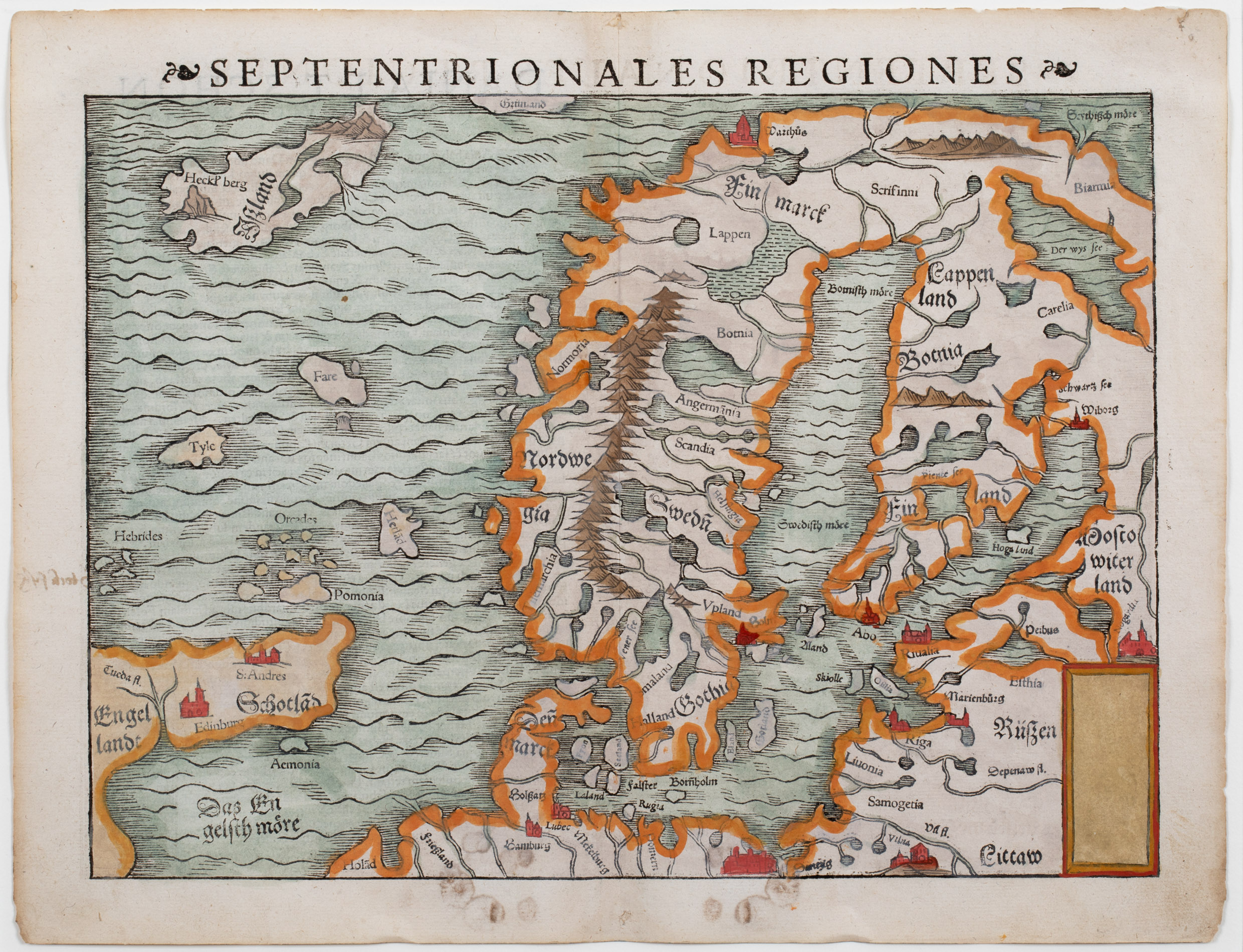
The „Cosmographia“ was filled with maps, views and rich descriptions of places throughout Europe and beyond. One of the most fascinating woodcuts is „Gemeine beschreibung aller mittnächtigen Länder …“ which is loosely based on Olaus Magnus‘ „Carta Marina“ in 1529 (in Latin editions in that language „Septentriones Regiones …“)
Most of Münster’s work was published by his step-son Heinrich Petri (1508 – 1579) and his son Sebastian Henric Petri (1545 – 1627), both printers based in Basel, Switzerland.
Map Details
This map is rather unique and rare because it is the second state of Münster’s map of 1540 (No. 186), first published in 1545, taken from a Latin edition of „Cosmographia universalis“. It is no longer based on Jacob Ziegler’s map of 1532 but on Olaus Magnus‘ „Carta Marina“ of 1939.
The title is written on top of the map. The rectangle cartouche in the lower right corner is empty. The map covers Scandinavia, a small part of Russia, the Baltic Region, the Northern part of Germany, the eastern part of England „Engellandt“, Scotland „Schotlad“, a group of small islands („Hebrides“, „Orcades“ (Orkneys), „Hetlad“ (Shetlands), „Pomonia“ (?), „Fare“ (Faroes) and „Tyle“ which refers to „Thule“, the legendary island described by the Greek Pytheas in the 4th century BC.
In the upper left corner Iceland („Ißland“) is placed.
The content of Iceland is rather poor. The bishoprics Skalholt and Holar are missing. Only the famous volcano Hekla („Heckl‘berg“) is depicted as a mountain.