
Louis Brion de La Tour(1743 – 1803) & Louis Charles Desnos (1725 – 1805)
Louis Brion de la Tour was a French geographer and engraver. His family may have come from Bordeaux. Despite a prolific cartographical career and several important atlases to his name, little is known about his life which passed in scientific work. His official title was „Ingenieur Geographe du Roi“. His son of the same name was born in 1763 and published until his death in 1823. It is nearly impossible to distinguish the work of the father from the work of the son, as both used the same imprint and were active in roughly the same period. Much of their work was done in partnership with Louis Charles Desnos for whom they engraved maps.
Louis Charles Desnos was an instrument and globe maker, cartographer and bookseller based in Paris. He was born in Ponte-Sainte-Maxence, Oise, France as son of a cloth merchant and was later appointed „Royal Globemaker“ to the King of Denmark, Christian VII. for which he received a stipend of 500 Livres annually and in return sent the king roughly 200 Livres worth of maps, books and atlases each year. His career may have had something to do with his acquiring the inventory of the map, globe and instrument seller Jacques Hardy, whose son Nicolas‘s widow he married. Desnos was a sharp business man and produced a substantial corpus of work. Despite or perhaps because of the sheer quantity of maps he published and because of his rather underhand way of acquiring inventory from other cartographers and publishers his reputation was poor among serious cartographic experts.
The most notable work of Brion de la Tour and Desnos is regarded to be their „Atlas general, civic, ecclesiastique, methodique et elementaire pour l‘etude de la geographie et de l‘histoire“ from about 1764 with subsequent reissues until about 1790. I was intended for use by the „young nobles“ of the Ecole Royale Militaire“, but also proved popular with general audience. Typically maps from the atlas feature an elaborate rococo decorative border, containing a smaller map and a descriptive text on either side of the map. This unusual combination required a special production technique which allowed the publisher maximum flexibility. Map and border were printed from two separate plates with the text glued down sheets at the time of publication.
Therefore different variants of this atlas can be found, with and without a decorative border, different borders, with and without the descriptive text, different languages, depending upon where the atlas was intended to be sold.
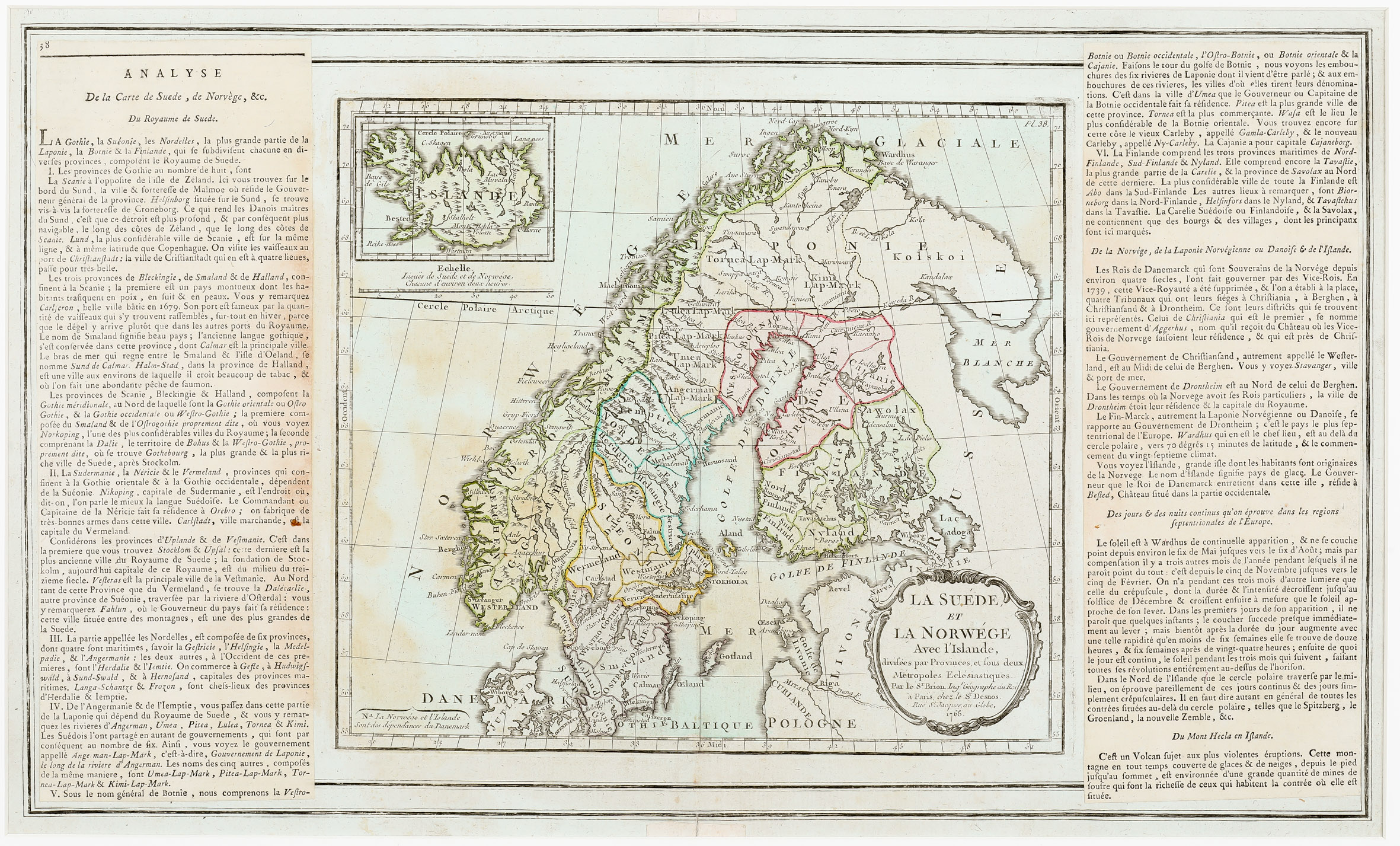
In the „Schulte Collection“ there are three different variants of the map of Scandinavia by Brion de la Tour and Desnos (No. 86, 101 and No. 132). The maps are identical, including the year 1766 in the cartouche, but different with regard to borders and descriptive texts. No. 101 is from one of the first editions of the atlas in which no descriptive texts exist. Clouet‘s map of 1787 (No. 147) is in the same style with colums on either side but the map itself is completely different.
Map details
This map is without border. The heading of the descriptive text in the left column is: „ANALYSE De la Carte de Suede, de Norvege, &c. Du Royaume de Suede“. The clarification „Article Premier“ which is added in No. 86 is missing. The French text in the columns on either side contains geographical information about the area.
The columns are wider than in No. 86 so that the text on this page of the atlas is longer. Therefore this map includes the beginning of the description of „Du Mont Hecla en Islande“.
The map is embellished with a title ornate cartouche in the lower right corner, naming the authors: „Par le Sieur Brion, Ingenieur Geographe du Roi, a Paris, chez le Sieur Desnos“.
The map shows Scandinavia, the Baltic region, the western part of Russia
and Poland, with an inset map of Iceland in the upper left quadrant. The whole map has only a few place names; this also applies to Iceland.
The map of Iceland is of the Knoff type. „Islande“ is printed across the depiction of the country which is without detailed information. In the interior some mountain ranges are depicted, only „Mont Hecla Volcan“, the bishoprics Skalholt and Holar („Hola“), both with church symbols, and „Lac Myvatn“ are named. The Arctic Circle is marked nearly to perfection.
Underneath the map of Iceland there are a distance scale („Echelle“) and a hint explaining the time change of two hours between Iceland and Sweden/Norway. In the lower left corner the information is given that Norway and Iceland are „dependances“ of Denmark.