
Sebastian Münster (1488 – 1552)
born in Ingelheim, near Mainz, was a German cartographer, cosmographer and Professor of Hebrew. As a young man, he joined the Franciscan order in which he became a priest and then studied geography at the University of Tübingen. In 1518 he moved to Basel where he started to publish a Hebrew Grammar and three years later he moved again, to Heidelberg where he continued to publish Hebrew texts. After converting to Protestantism in 1529, he took over the chair of Hebrew at the University of Basel where he edited his main Hebrew work, a two-volume Old Testament, accompanied by a Latin translation. He also published a book on the basics of geometry „Rudimenta Mathematica“.
In 1525 Sebastian Münster published his first known map, a map of Germany, and in 1535 he released a map of Europe „Mappae Europae“. The first map of the Nordics titled „Schonlandia“ appeared in „Geographia“ which he compiled in 1540. Its geographic content is based on Jacob Ziegler‘s map of 1532.
Sebastian Münster‘s famous work „Cosmographia“ of 1544 with 24 double-paged maps was one of the greatest geographical and historical works and most popular books of the 16th century, until the advent of Ortelius‘ „Theatrum“. This earliest German-language description of the world passed through numerous editions in 100 years in different languages including Latin, French, Italian, English and Czech until 1628, long after his death. More than a half of all editions was in German language.
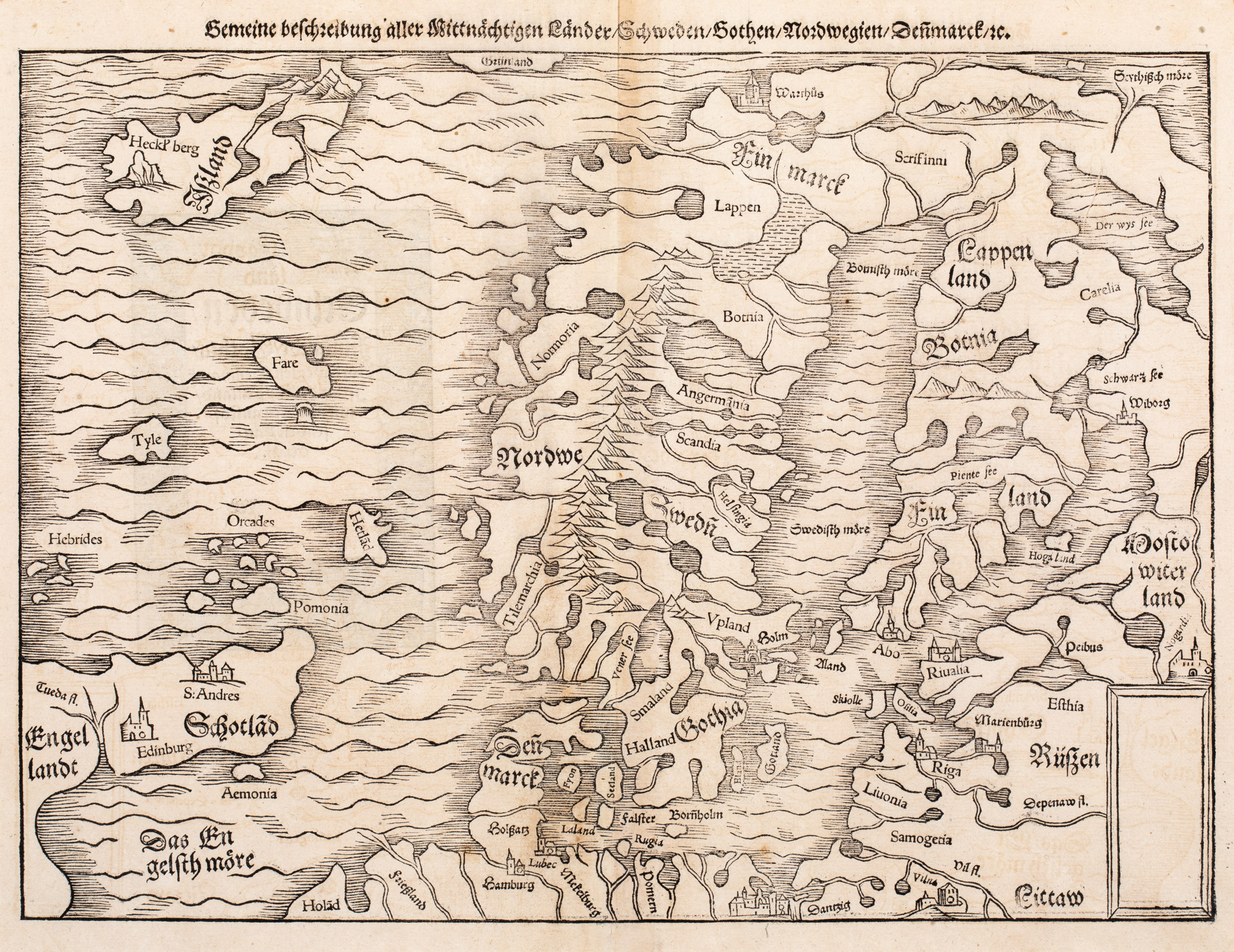
The „Cosmographia“ was filled with maps, views and rich descriptions of places throughout Europe and beyond. One of the most fascinating woodcuts is „Gemeine beschreibung aller mittnächtigen Länder …“ which is loosely based on Olaus Magnus‘ „Carta Marina“ in 1529 (in Latin editions in that language „Septentriones Regiones …“)
Most of Münster’s work was published by his step-son Heinrich Petri (1508 – 1579) and his son Sebastian Henric Petri (1545 – 1627), both printers based in Basel, Switzerland.
Map details
This woodcut map comes from the German edition of Sebastian Münster‘s Cosmography, titled „Cosmographey oder beschreibung aller Länder …“, published in 1578 by Heinrich Petri in Basel. It is a striking example of the second Münster map of Scandinavia, first issued in 1545 and in use until 1579. It replaced the very rare first edition of the map which appeared 1544 in only the first three editions of Münster‘s Cosmographia. The third edition was printed until 1628 (No. 67).
In the lower right corner an empty scripture cartouche is to be found. The title is printed above the map which shows Scandinavia, the western part of Russia, the Baltic States, the northern part of Germany, the northeast of England, Scotland including the Hebrides, Orkney and Shetland Islands and the Faroe Islands. There is another island named „Tyle“ which refers to „Thule“, the legendary island described by the Greek Pytheas in the 4th century BC.
Iceland is also included but there is only one place-name next to a volcano „Heckl‘berg“ (Hekla).