
Giovanni Antonio Magini (1555 – 1617)
was an Italian astronomer, astrologer, mathematician and cartographer. Born in Padua, he received a doctorate in philosophy from the University of Bologna in 1579 before publishing three years later a major astronomical treatise, „Ephemerides coelestium motuum“. In 1588 he took over the Chair of Mathematics at the University of Bologna. His competitor was – amongst others – the young Galileo Galilei and held the position for the rest of his life.
As an astronomer, Magini‘s beliefs were original but based on the established world-view while the nine years younger Kopernikus had revolutionary ideas.
Magini supported a geocentric system of the world, in preference to Copernicus‘ heliocentric system. Magini‘s system consisted of eleven rotating spheres, which he described in his „Novae coelestium orbum theoricae congruentes cum observationibus N. Copernici“ (Venice 1589), in which he also writes about „absurd hypotheses, such as Copernicus imagined“.
In his „De Planis Triangulis“ (1592) he described the use of quadrants in surveying and astronomy and in 1606 devised extremely accurate trigonometric tables, followed by the work „De astrologica ratione“ one year later.
As a cartographer, he published a commentary on Ptolemy‘s „Geographia“ (Cologne 1596). His life‘s work was the preparation of the „Atlante geografico d‘Italia“, printed posthumously by Magini‘s son Fabio in 1620. His production begun already in 1594 but it proved expensive and financially difficult. Magini did not do any of the mapping himself.
Map details
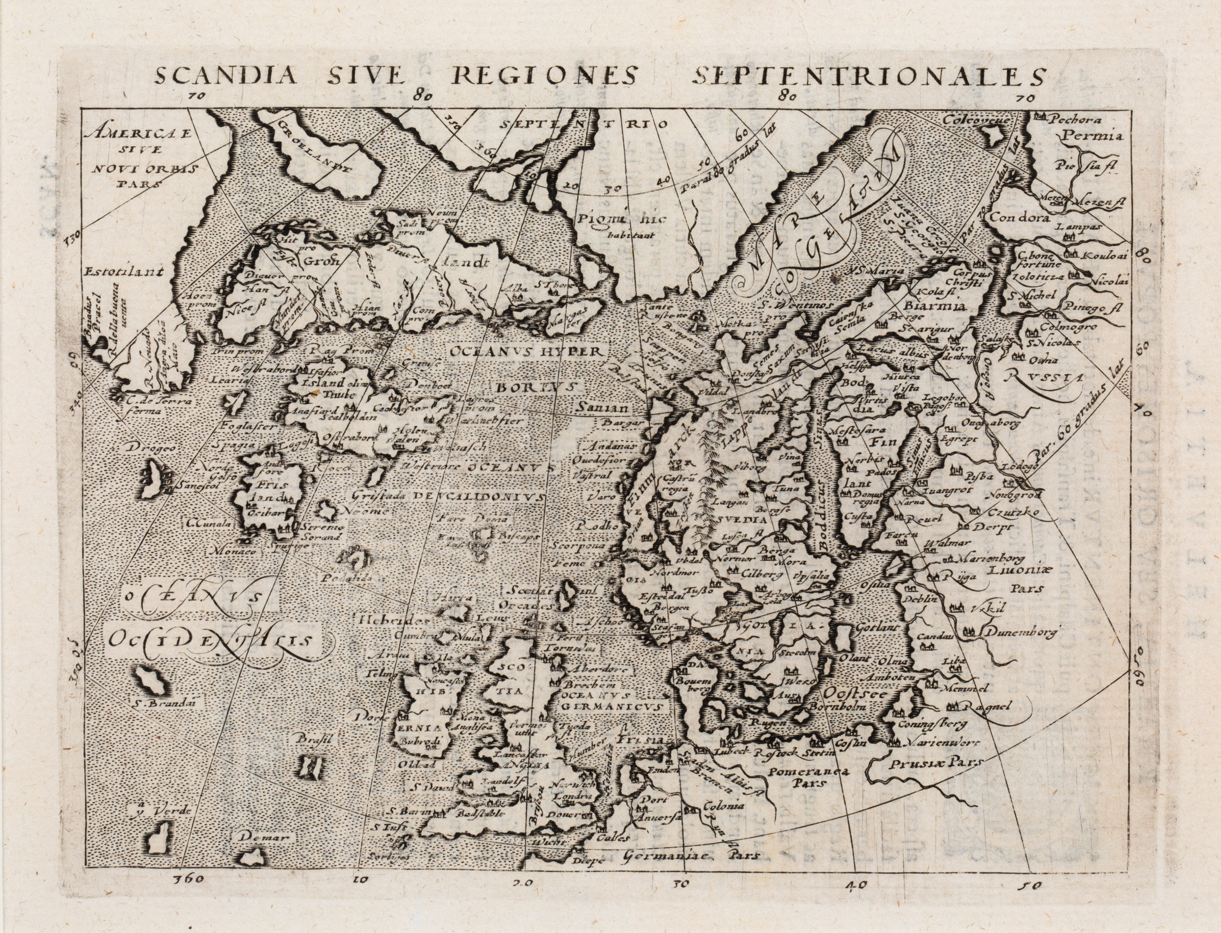
This copperprint map of the Arctic is extracted from the „Geografia cioe de scrittione universale de la terra“, universal description of the earth by Claudius Ptolemy, engraved by Giralomo Porro. Magini bases his map on Abraham Ortelius map of the North „Septentrionalium Regionum Descrip.“ (No. 56).
Magini published the last 16th century edition of Ptolemy in 1596 in Latin in Venice. The following year in Cologne, Petrus Keschedt published an unauthorized edition, but with newly engraved plates. Although the Scandinavia map is similar, the later version is about 0,5 cm narrower, with small differences in lettering and typography.
This rare map is the Keschedt version of 1597. It covers the area between „Russia“ in the east and „Estotilant“ in the west, a region that appeared first on the Zeno map, located where Labrador, Quebec and Newfoundland are situated on nautical charts. Greenland is shown as two separate islands, „Groelandt“ and „Groenlandlandt“. In the far North there is an area described as „Pigmei hic habitant“ (Pygmies live here). The map also covers the Faroe Islands („Fare“) and the British Isles, Scandinavia, the Baltic region and parts of Prussia, Pomerania and Germany.
Iceland is named „Island olim Thule“ (Iceland once Thule) which refers to the legendary island described by the Greek Pytheas in the 4th century BC.
There are a only few place-names, amongst them the bishoprics Skalholt („Scalboldin“) and Holar („Holem“), both with church symbols. The volcano Hekla is not depicted.
What makes this map fascinating is the inclusion of many non-existing islands. Prominent is the large island of „Frisland“ with lots of place names. Other „mystical“ islands are „Brasil“, „S. Brandain“, „Podalida“, „Drogeo“, „Icaria“, „Grislada“ and „Neome“. Several of these islands were thereafter incorporated in nearly every map of the North Atlantic for the next 100 years.