Herman Moll (1654 – 1732)
was an important map publisher and engraver. Most likely he was a German from Bremen who moved to London in 1678. First Moll worked as an engraver for Moses Pitt on the production of the „English Atlas“. Around the turn of the century he set up his own business. Most of Moll‘s maps, covering all parts of the world, were produced as loose sheets that would be bound to order, however, he also published several important atlases late in his career: the „Atlas Manuale“ (1709), the „Atlas Geographus“ in five volumes (1711-7), the „New and and Complete Atlas“ (1719) and the „Atlas Minor“ (1729). After Moll‘s death the Bowles family (1714 – 1832) took over possession of his stock. Due to his popularity and the sheer volume of his work, Moll‘s maps continued to dominate the British market for decades.
Map details
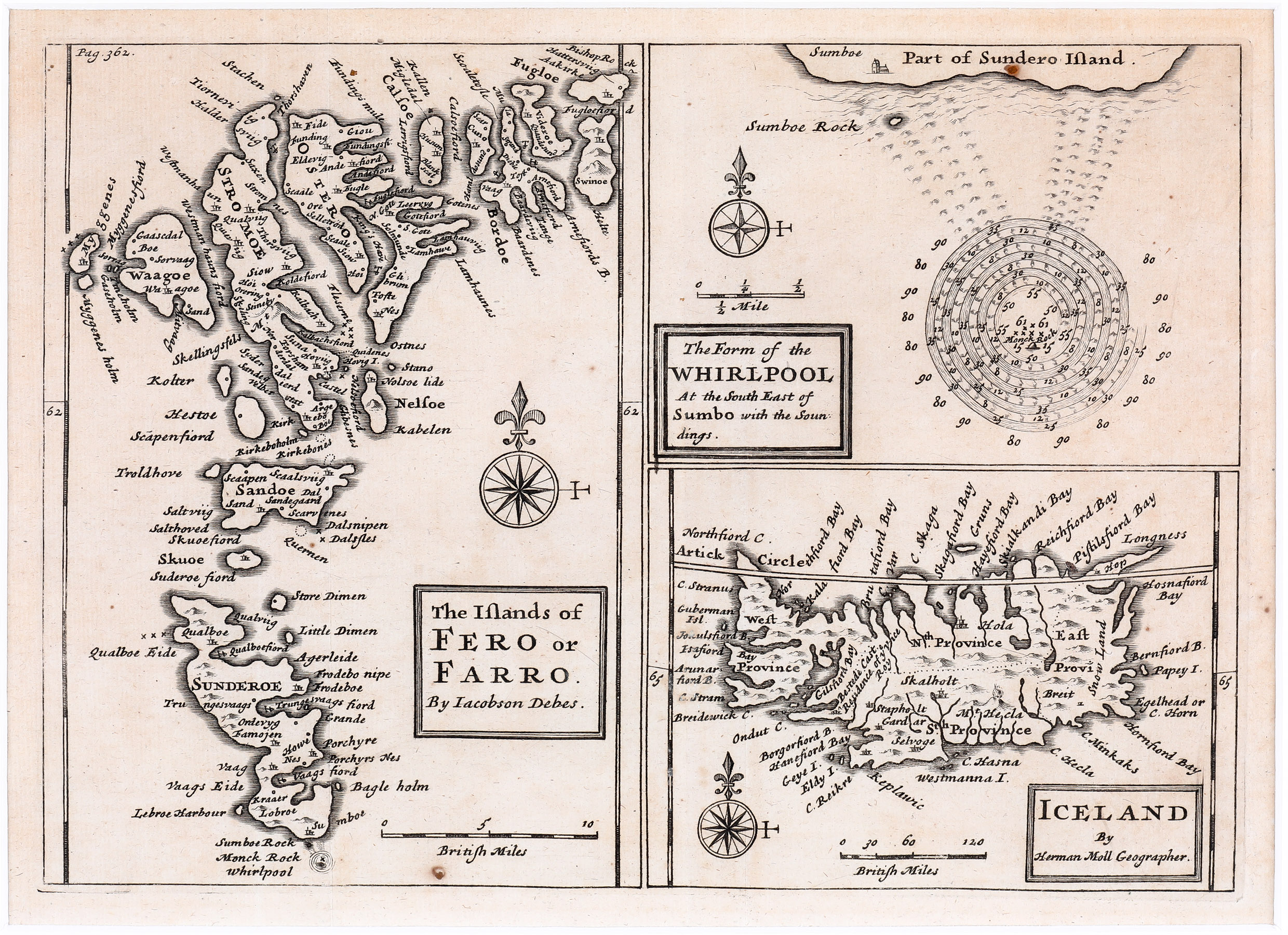
The Islands of Fero or Farro by Jacobson Debes.
The Form of the Whirlpool At the South East of Sumbo with the Soundings.
Iceland by Herman Moll Geographer.
This chart is a compilation of three maps on a single sheet, contained in a 17th century book on the Faroe Islands written by Jacobson Debes. It was also issued by Carrington Bowles in London in 1784.
All maps are decorated with a compass rose and a distance scale. The depiction of the Faroe Islands fills the left half of the sheet. They have been historically treacherous for mariners due to unpredictable currents and tides surrounding them. One of the most curious and legendary results of these currents is the great Maelstrom which is to be seen at the top right. This mighty whirlpool once roared at the southern tip of Sunderö (today Suduroy Island) around a sheer pinnacle of rock called Monek which was told to resemble a monk from one side and a sailing ship from the other. Reports say that the whirlpool was over a mile in diameter. In 1894 much of Monek Rock crumbled into the sea, creating a dangerous underwater reef and displacing the unique convergence that created Maelstrom.
In the lower right quadrant is a map titled „Iceland drawn by Herman Moll Geographer“.
It shows four primary provinces and there is a strange place-name: „Bestede Cast. Residence of y Vice Roy“. The bishoprics Skalholt and Holar are depicted with little churches and Hekla erupting. The western part of the country is particular out of shape (looks like an antler). The Arctic Circle is drawn too far south.
Comments by the collector
My wife Gisela and I had travelled to the Faroe Islands and when this map was offered we thought it is a nice souvenir. Later we decided to search for other maps depicting Iceland with its neighbouring islands. Over time they have become a specific category in the „Schulte Collection“.