
Jacques Nicolas Bellin (1703 – 1772)
was a French hydrographer, geographer and member of the intellectual group „Philosophes“. Born in Paris, at the age of 18 years, he was appointed hydrographer to the French Navy. In 1741 Bellin became the first „Ingenieur de la Marine“ of the „Depot des Cartes et Plants de la Marine“ (French Hydrographical Office“) and was named „Hydrographe Officiel du Roy de France“. During his reign the Depot published a prodigious number of maps and atlases, e.g. the „Atlas Maritime“ (1764) and the „Petit Atlas Maritime“ (1764). Bellin also contributed a number of maps to the „Histoire Generale des Voyages“ of Antoine Francois Prevost d‘Exiles“ (1697 -1763), a French author and novelist (e.g. „Manon Lescaut“), simply known as „l‘Abbe Prevost“. Prevot‘s collection was printed for the first time in 1746 and it continued until 1789, more than 20 years after his death. Many of Bellin‘s maps were copied by other map makers.
Bellin‘s work focussed on function and accuracy, tending to be less decorative than the 17th century cartographic images, thus gaining France the leading role in European cartography in the 18th century.
Map details
This map is part of the largest and most important German-speaking collection of travel books of the 18th century, titled: „Allgemeine Historie der Reisen zu Wasser und zu Lande …“ which was published between 1747 and 1774 in 21 volumes in Leipzig by Arkstee and Merkus. It has been edited and translated by Johann Wolfgang Schwabe (1714 – 1784) from Prevost‘s „Histoire Generale des Voyages“.
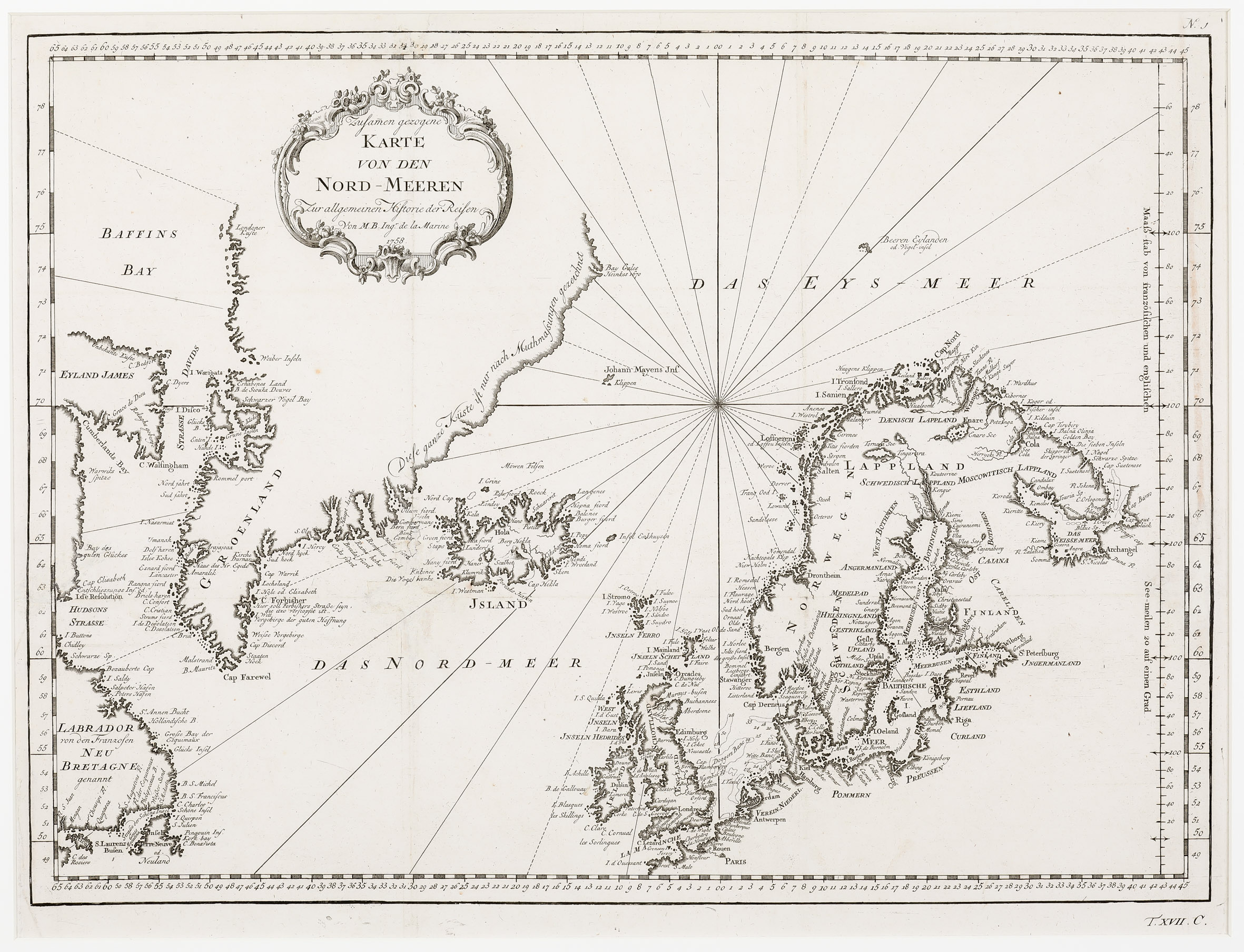
The map is decorated with an ornamental title cartouche in the upper part, a compass rose nearly in the center and rhumb lines. It gives an excellent overview of the North Atlantic and shows Iceland („Island“), most of Greenland, Baffin Island („Eyland James“) and Labrador („von den Franzosen ‚Neu Bretagne‘ genannt“, Jan Mayen („Johann Mayens Inf“),the Bear Island („Beeren Eylanden“), the Faroe Islands, the British Isles, Scandinavia, the Baltic region, Pomeria („Pommern“) and Prussia („Preussen“). The map is well engraved and detailed but not accurate in parts, for instance Greenland. The coast stretches too far south and the eastern coastline runs wrongly as the author admits: „Diese ganze Küste ist nur nach Muthmaßungen gezeichnet“ (drawn only on speculation). European capitals such as Paris, Amsterdam, London, Dublin, St. Petersburg, Stockholm and Oslo are labelled, along with numerous smaller cities. The Arctic Circle is not marked on the whole map.
„Island“ is written underneath the depiction of the country. The shape itself looks rather disproportionate and different from the shape which was published by Niels Horrebow earlier (in 1752) and Bellin normally used for other maps at the time, perhaps because that type was common on many sea charts (islandskort.is). Most information on Iceland is coastal. In the interior only the bishoprics Skalholt („Scalhot“) and Holar („Hola“), both without church symbols, are labelled. Hekla („Berg Hekla“) is depicted in an eruption.