
Jacques Nicolas Bellin (1703 – 1772)
was a French hydrographer, geographer and member of the intellectual group „Philosophes“. Born in Paris, at the age of 18 years, he was appointed hydrographer to the French Navy. In 1741 Bellin became the first „Ingenieur de la Marine“ of the „Depot des Cartes et Plants de la Marine“ (French Hydrographical Office“) and was named „Hydrographe Officiel du Roy de France“. During his reign the Depot published a prodigious number of maps and atlases, e.g. the „Atlas Maritime“ (1764) and the „Petit Atlas Maritime“ (1764). Bellin also contributed a number of maps to the „Histoire Generale des Voyages“ of Antoine Francois Prevost d‘Exiles“ (1697 -1763), a French author and novelist (e.g. „Manon Lescaut“), simply known as „l‘Abbe Prevost“. Prevot‘s collection was printed for the first time in 1746 and it continued until 1789, more than 20 years after his death. Many of Bellin‘s maps were copied by other map makers.
Bellin‘s work focussed on function and accuracy, tending to be less decorative than the 17th century cartographic images, thus gaining France the leading role in European cartography in the 18th century.
Map details
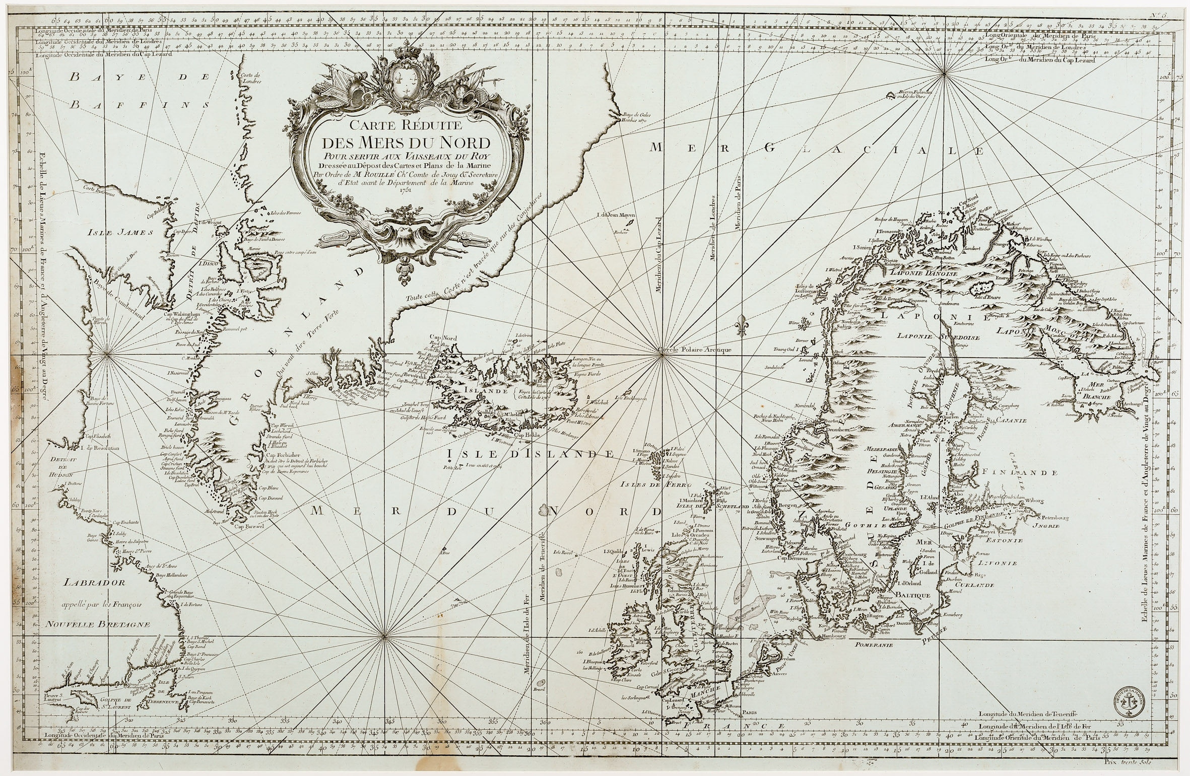
This very rare map which is not mentioned in literature was published by Bellin for the Depot de la Marine, as can be seen from the seal in the lower right corner. It is decorated with an ornamental title cartouche in the upper part, a compass rose nearly in the center and rhumb lines. It gives an excellent overview of the North Atlantic and shows Iceland („Isle D’Islande“), most of Greenland, Baffin Island („Isle James“) and Labrador („appelle par les Francais ‚Nouvelle Bretagne‘“), Jan Mayen, the Bear Island („Beeren Eyland ou Isle des Ours“), the Faroe Islands, the British Isles, Scandinavia, the Baltic region, „Pomeranie“ and „Prusse“. The map is well engraved and detailed but not accurate in parts, for instance Greenland. The coast stretches too far south and the eastern coastline runs wrongly as the author admits: „Toute cette coste n’est tracee que sur des Conjectures“ (drawn only on speculation). European such as Paris, Amsterdam, London, Dublin, St. Petersburg, Stockholm and Oslo are labelled, along with numerous smaller cities. The Arctic Circle runs across the whole map but is drawn too much south.
„Isle D’Islande“ is written underneath and „Islande“ across the depiction of the country. The shape of Iceland itself looks different to those Bellin normally used for other maps and very similar to the one which was published by Niels Horrebow in 1752. According to islandskort.is the map was published in 1751. This is all the more astonishing as behind „Islande“ there is a note: „Voyez la Carte de Cette Isle de 1767“ (See the map of this island of 1767). It is obvious that this map was published in 1767 or later.
Most information on Iceland is coastal. In the interior the bishoprics Skalholt („Scalhlol“) and Holar („Holum“), both without church symbols, are labelled. Hekla („Mt hekla Volcan“) is depicted in an eruption. Unusually and probably for the first time Krafla („M. Krafl Volcan“) is named on a map covering Iceland.