
Gerard van Keulen (1678 – 1726)
was a Dutch cartographer and publisher who mainly produced nautical charts and atlases in the tradition of his father Johannes van Keulen (1654 – 1715), the founder of the firm which should become the biggest and most influential name in the history of Dutch sea charts.
Born in Deventer, Johannes established himself in Amsterdam in 1678. In 1680 he gained privilege from the States of Holland and West Friesland for the publication of pilot guides and sea atlases. In that year Johannes released the „Zee-Atlas. De grote nieuwe vermeerderde Zee-Atlas ofte Water-Wereld“ which became immensely popular and was steadily re-produced until 1734. In 1681 „De Nieuwe Grote Ligtende Zee-Fakkel“ (Shining Sea Torch“) appeared. The atlas had charts compiled by Claes Jansz. Vooght and artwork from Jan Luyken. This five volume-work was published in several editions until 1865 and made Johannes van Keulen famous. There were translations in French, English, Spanish and Italian language.
His son Gerard was endowed with talent and by doing an internship with his father, Gerard became a skillful engraver. He was also proficient in mathematics and navigation and established the scientific basis of the van Keulen firm. In 1714 he was appointed hydrographer to the Dutch East India Company and the family remained chart makers until the company‘s liquidation.
After Gerard van Keulen‘s death at the age of only 49 years, his son Johannes II. van Keulen (1704 – 1755) carried on the business. He is known in particular for his publication in 1753 of a sixth volume of the „Zee-Fakkel“ which contained new charts of the route to the East Indies and was re-printed until 1773.
When Johannes van Keulen the Younger died, his son Gerard Hulst van Keulen (1733 – 1801), great grandson of the founder of the „Empire“, took over the firm. He was responsible for the final true van Keulen editions of the family‘s signature product, the „Zee-Fakkel“. When he died the business was continued by his son Johannes Hulst van Keulen and after his death in 1844 the firm passed out of family hands and flourished under different names until 1885.
Map details
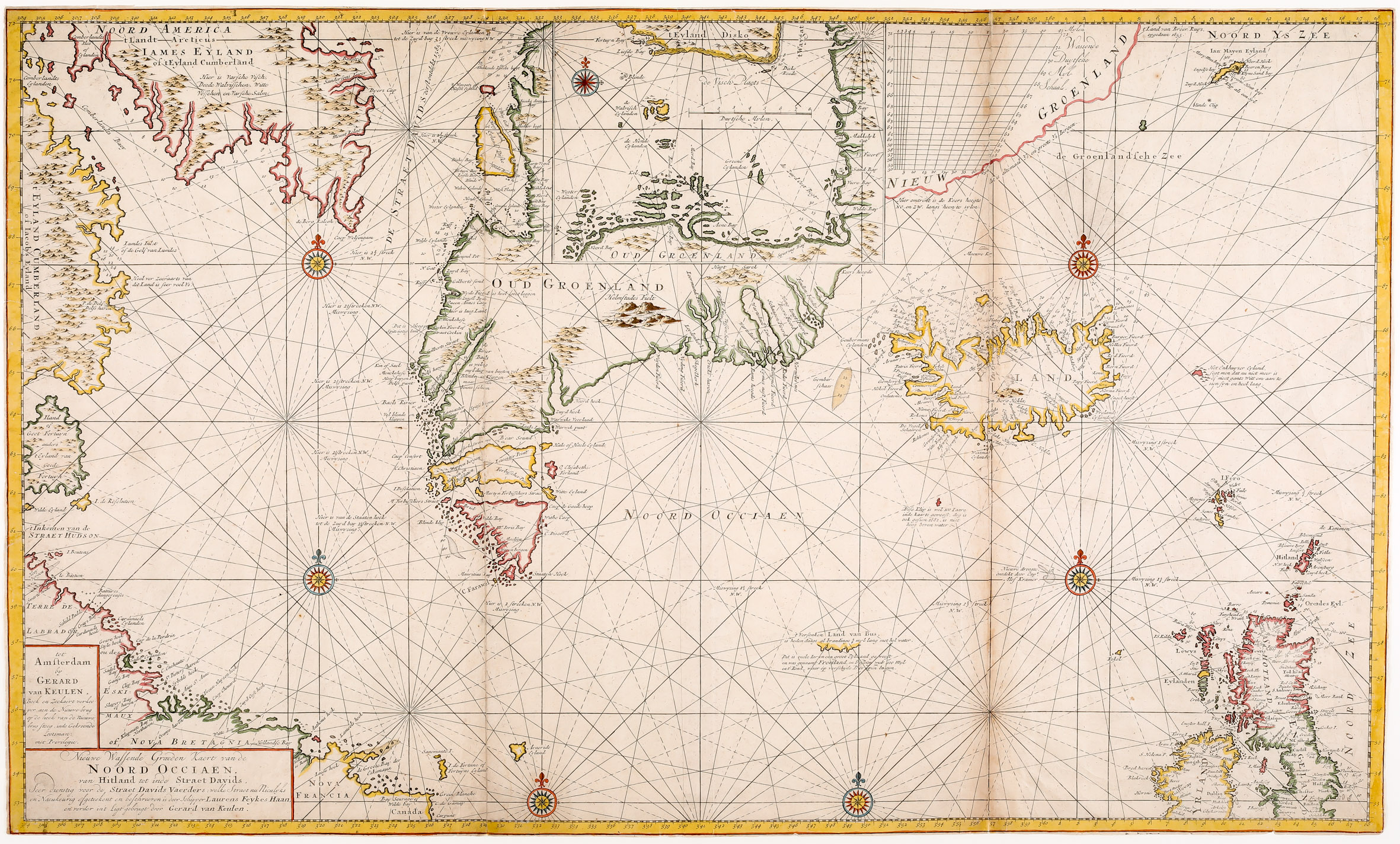
This map is of an edition of the „Groote Nieuwe VermeerderZee Atlas ofte Water-werelt“.
of the Arctic Ocean is of outstanding quality and extremely rare. Curiously, there is hardly any mention in the literature besides this one: „This map is from an edition of De Groote Nieuwe Vermeerderde Zee Atlas ofte Water-werelt. The outline of Iceland is based on other Dutch Nautical charts. The Western Fjords have turned into two peninsulas, one pointing west and the other north, and the coastline is rather rough“ (islandskort.is).
The sea chart shows in the West: the „Noord America“ which is today‘s Nunavut in Canada, the Davis Strait („De Straet Davids“), Baffin Island („Iames Eyland“), „t Eyland Cumberland“, which are islands off the coast of Georgia, „Nova Bretagnia“ which normally stands for Labrador but there is also „Terre de Labrador“, „Nova Francia“ which is the name of the first French colony in Acadia, and „Canada“.
„Oud Groenland“ (Old Greenland) is in the center of the map. Above it is an inset depicting the region south of Disko Island („t‘ Eyland Disko“) which includes a compass rose and a mileage scale. East of it „Nieuw Groenland“ (New Greenland) is placed which mainly shows a „Wassende Duytsche Myl Schaal“. At the end of the coastline the sentence is to be found: „t‘ land van Broer Ruys opgedaan 1855“. Underneath „Oud Greenland“, Iceland („Ysland“) is placed just in the center of the map. South of it a klip is depicted which does not exist any more but also a newly discovered „Cap‘ Alof Kramer“. Further south the coastline of an island is to be seen with the comment: „t‘Versenken Land van Bus“ which explains that the island of Frisland no longer exists.
In the East the mysterious „Enkhuyser Eyland“ and „Ian Mayen Eyland“ are to be seen, furthermore most of the British Isles.
Six attractive compass roses all over the map plus three others, all connected by rhumb lines, make this map even more attractive.
The outline of Iceland is based on other Dutch nautical charts. The western fjords have turned into two peninsulas, one pointing west and the other north. Along the coastline there are plenty of names mainly of fjords, in the interior only one: Hekla („Den Berg Hekla“) in an eruption.