
Gerard van Keulen (1678 – 1726)
was a Dutch cartographer and publisher who mainly produced nautical charts and atlases in the tradition of his father Johannes van Keulen (1654 – 1715), the founder of the firm which should become the biggest and most influential name in the history of Dutch sea charts.
Born in Deventer, Johannes established himself in Amsterdam in 1678. In 1680 he gained privilege from the States of Holland and West Friesland for the publication of pilot guides and sea atlases. In that year Johannes released the „Zee-Atlas. De grote nieuwe vermeerderde Zee-Atlas ofte Water-Wereld“ which became immensely popular and was steadily re-produced until 1734. In 1681 „De Nieuwe Grote Ligtende Zee-Fakkel“ (Shining Sea Torch“) appeared. The atlas had charts compiled by Claes Jansz. Vooght and artwork from Jan Luyken. This five volume-work was published in several editions until 1865 and made Johannes van Keulen famous. There were translations in French, English, Spanish and Italian language.
His son Gerard was endowed with talent and by doing an internship with his father, Gerard became a skillful engraver. He was also proficient in mathematics and navigation and established the scientific basis of the van Keulen firm. In 1714 he was appointed hydrographer to the Dutch East India Company and the family remained chart makers until the company‘s liquidation.
After Gerard van Keulen‘s death at the age of only 49 years, his son Johannes II. van Keulen (1704 – 1755) carried on the business. He is known in particular for his publication in 1753 of a sixth volume of the „Zee-Fakkel“ which contained new charts of the route to the East Indies and was re-printed until 1773.
When Johannes van Keulen the Younger died, his son Gerard Hulst van Keulen (1733 – 1801), great grandson of the founder of the „Empire“, took over the firm. He was responsible for the final true van Keulen editions of the family‘s signature product, the „Zee-Fakkel“. When he died the business was continued by his son Johannes Hulst van Keulen and after his death in 1844 the firm passed out of family hands and flourished under different names until 1885.
Map details
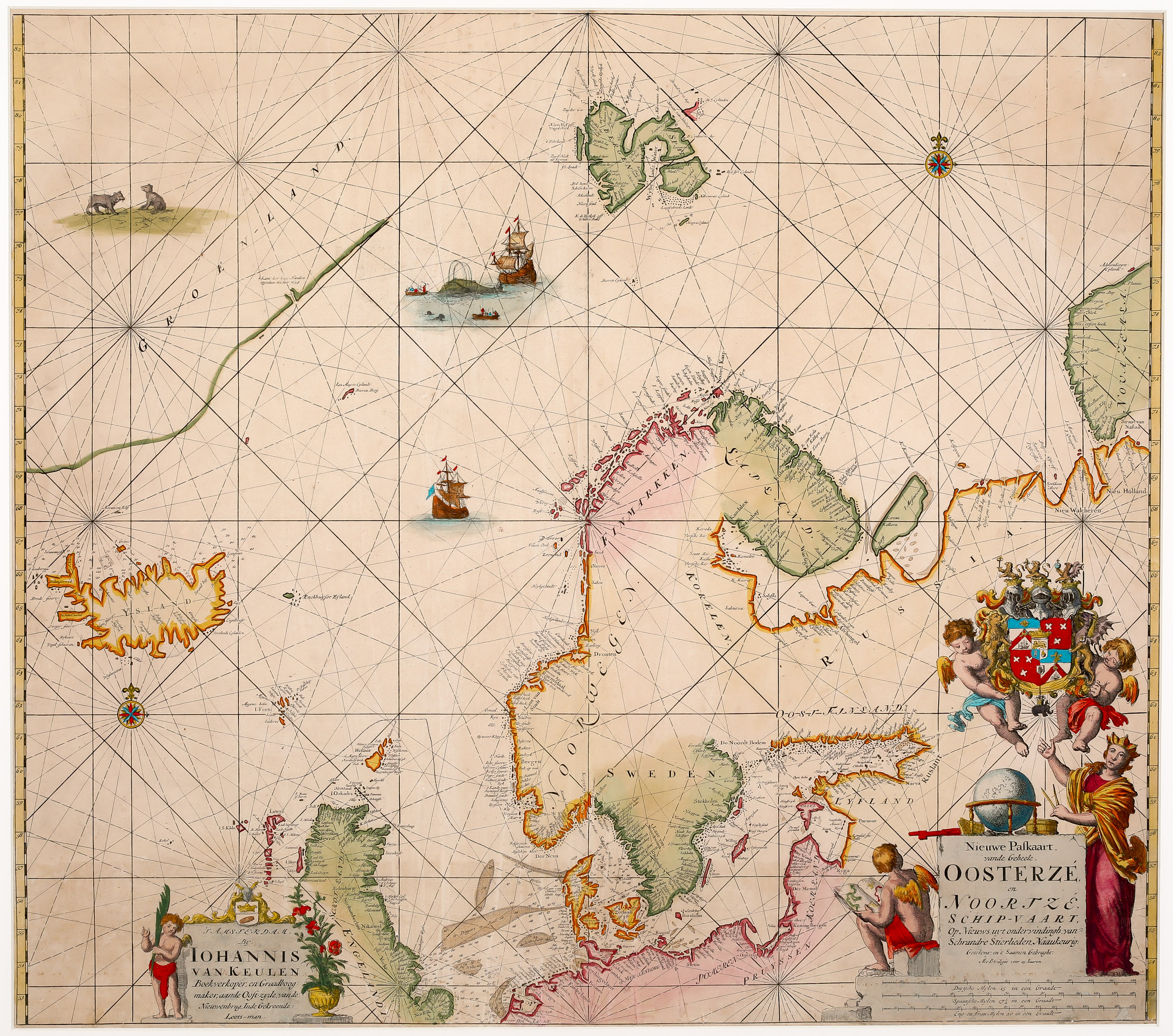
A very rare sea chart which covers the east coast of Greenland, Iceland, Spitsbergen, northern Scotland, Scandinavia and the Baltic region, with traces of Nova Zembla to the Northeast. With the exception of Greenland, the coastlines and regions are well outlined. The bottom left contains a beautiful ornamental cartouche which identifies „Iohannis van Keulen“ as the bookseller and mapmaker. The bottom right has an attractive title cartouche accompanied by a woman with a globe and two cherubs, one of whose is reading an atlas, the other bears a coat of arms. Underneath the title cartouche three distance scales are to be found.
The illustrations in this map are superior to most others in the period. Instead of having normal ships and sea monsters, there are detailed whaling ships and polar bears in historically accurate locations. There are two ornamental compass roses, one in the middle of the left part of the map, one in the upper right and additionally three others in the upper left part, all connected by rhumblines.
On the map of Iceland itself, only a few place names are to be found along the coastline. In the interior the island is completely empty.