
Nicolo Zeno (1326 – 1402) and Antonio (died c. 1403)
were noted Italian navigators from Venice who flourished in the second half of the 14th century. They were brothers of the Venetian naval hero Carl Zeno. The Zeno family was an established part of the aristocracy of Venice and held the franchise for transportation between Venice and the Holy Land during the Crusades.
They came to prominence in 1558 when one of their descendants, Nicolo Zeno the Younger (1515 – 1565), an hydraulic engineer who later became a historian and wrote about the history of Venice, decided to initiate a book describing the explorations of his ancestors Nicolo and Antonio Zeno in the North Atlantic in the 1390s. According to Ginsberg (p. 77) it was published under the title: „De i Commentarii del Viaggio in Persia … et dello Scoprimento dell‘ Isole Frislanda, Eslanda, Engrouelanda, Estotilanda, & Icaria, fatto sotto il Polo Artico, da due fratelli Zeni …, In Venetia Per Francesco Marcolini. M D LVIII.“ (Annals of the Journey in Persia … And of the Discovery of the Islands Frislanda, Eslanda, Engrouelanda, Estotilanda, and Icaria, made under the North Pole, by the two brothers Zeni …) and is now held by the Bibliotheca Marciana in Venice.
In the introduction the publisher explains that the narrative was written by Nicolo Zeno the Younger, great-nephew of Nicolo and Antonio Zeno, the two navigators whose travels are described in the text. He reports that as a child he has found five long letters in the family library and not comprehending their value he had irreparably ruined them
so that a considerable part of the information was lost but that he was able to proceed with a careful editing of their story, adding parts of the missing text on his own to connect the passages of the letters. Nicolo the Younger also presented a nautical map which came to be known in history as „Zeno Map“.
The story of the Zeno brothers discoveries is as follows:
On his voyage to the North Nicolo stranded on an island between Great Britain and Iceland called Frislanda which is described being larger than Ireland. By chance Nicolo is rescued by Zichmni, Prince of Frislanda. Nicolo invited Antonio to join him what he did. The brothers attacked Zichmni‘s enemies for 14 years. Their fights led them to the surrounding islands, presumably enabling them to make the famous map. Zichmni attempted to take Islanda but failed; instead he took the small islands to the east. Nicolo sailed to Greenland where he came upon St. Thomas, a monastery in Greenland where he enjoyed hot springs. Four years later Nicolo died in Frislanda.
Zichmni received the news that a group of lost fishermen from Frislanda have returned after an absence of over 25 years. They described their landfall in the far west in unknown lands called „Estotiland“ with a Latin-speaking population and „Drogeo“ with lots of strange beasts and cannibals. Inspired by the tales of the fishermen Zichmni and Antonio undertook a voyage to the west and encountered a large island called „Icaria“ where the inhabitants made clear that visitors are not welcome. After efforts of making landfall had failed they sailed north and reached „Engrouelanda“. Zichmni was enthralled with this new land and explored it while Antonio left and sailed for his native Venice where he died around 1403.
An English translation of the book was published by the Hakluyt Society (done by Richard Henry Major) under the title „The Voyages of the Venetian Brothers Nicolo and Antonio Zeno, to the Northern Seas in the XIVth Century, comprising the latest known Accounts of the Lost Colony of Greenland; and of the Northmen in America before Columbus“ in 1873.
Widely accepted at the time of publication, the so-called „Zeno Map“, for „the next 40 years .. influenced most maps that were made of Iceland“ (islandskort.is) and was incorporated into the works of leading cartographers. Ruscelli published a version of the Zeno Map in his maps of 1561 and 1574 (see No. 75 and 157), Gerardus Mercator adopted much of Zeno‘s map in his famous world map of 1569 and his North pole map of 1595 and Abraham Ortelius took over the mysterious islands in his map of the North Atlantic „Septentrionalium Regionum Descrip.“ of 1570 (see No. 56). „Frisland“ appeared on maps as late as the 1675 world map of Nicolaas Visscher.
The „Zeno Map“ was also used by English explorers Martin Frobisher (see No. 60) and John Davis in search of the Northwest Passage in the 1570s and 1580s.
In the 19th century the Zeno story and the map came under scrutiny. Most famously Frederick W. Lucas questioned the validity in „The Annals of the Voyages of the Brothers Nicolo and Antonio Zeno in the North Atlantic“ (1898) and accused Nicolo Zeno the Younger of making the map up, using islands found on other maps, and simply scattering them across the North Atlantic, and having commited a forgery.
Also most modern historians regard the map and the accompanying narrative as a hoax perpetrated by Nicolo the Younger to make a retro-active claim for Venice having discovered the New World.
Whatever the truth, the Zeno map and its islands are one of the most enduring mysteries in the history of cartography.
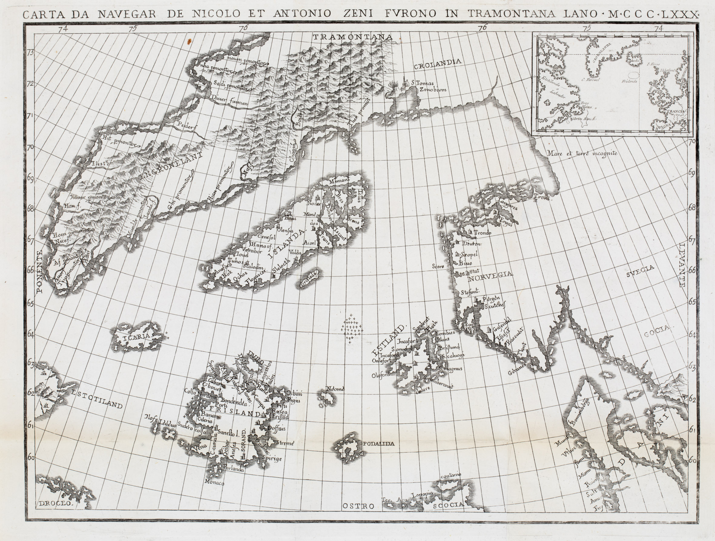
Map details
This copy of the Zeno Map from „Nouvelles des Voyages er des sciences Geographiques, published by J. B. Eyries and Conrad Malte-Brun, faithfully reproduces the original map of the North Atlantic and incorporates an inset map showing the full journey of the Zeno brothers „with a more recent version of Iceland“ (islandskort.is).
The map of the North Atlantic covers the area from „Estotiland“ and „Drogeo“ in the west to Scandinavia in the east. Greenland is named „Tramontana“ (North wind) and divided into the two parts of „Engronelant“ and „Crolandia“. Surprising are the depiction of an erupting volcano next to a monastery named „S Tomas Zenobium“ and the continuous coastline from Greenland to Scandinavia.
Iceland is depicted in a very strange shape stretching diagonally from south west to north east. Obviously it is taken from Olaus Magnus’ famous „Carta Marina“ of 1539
but „the mountains, rivers and all the pictures have gone and the ice flows off the east coast on Olaus‘ map have become islands“ (islandskort.is). There are five church symbols but only two can be allocated: „Scalodin“ to Skalholt and „Olensis“ to Holar.
What differentiates this map are the mysterious islands of the North Atlantic that nobody had heard of at that time and which are depicted in remarkable detail: (from west to east) „Estotiland“, „Drogeo“, „Icaria“, „Frisland“ (with 32 place-names), „Grislada“, „Neome“, „Podalida“ and „Estlanda“.
Centuries later geographers started investigations to retrace the Zeno brothers’ routes and to find out what is behind the names of these mysterious islands, which of them are existing in reality and which is their new name. It is now agreed that „Estotiland“ is presumed to be Nova Scotia including Labrador, „Drogeo“ the coastal area south of Newfoundland, „Estlanda“ the Shetland Islands and „Neome“ the Fair Isle or Foula. Obviously all the other islands including „Frisland“ may simply be an invention of the mapmaker(s).
Comments by the collector
This map was acquired from renowned Barry Lawrence Ruderman Antique Maps Inc., California in March 2023. Remarkable are these sentences in the description:
„This 19th Century example of the map is extremely rare on the market. We know of only 1 example of the map which has changed hands in the past 25 years“.