
Girolamo Ruscelli (1504 – 1566)
born in Viterbo, Tuscany was an Italian polymath, humanist and cartographer active in Venice during the early 16th century. He was not only a prominent writer on most varied subjects and a publisher but also an alchemist, mathematician, physician, writing pseudonymously as Alessio Piemontese. In his immensely popular book of alchemy „De Secreti Del Alessio Piemontese“ he described recipes for alchemical compounds, cosmetics, dyes, and medicines. It was reprinted for over two centuries and translated into numerous languages (French, English, German, Latin, Dutch, Spanish, Polish, Danish).
In 1561 Ruscelli issued an enlarged version of Giacomo Gastaldi‘s 1548 edition of Ptolemy‘s „Geographia“ (No. 70), published as „La Geografia di Claudio Tolomeo Alessandrino“ by Valgrisi. It is included newly engraved copperplates by Giulio and Livio Sanuti which were based generally on those of Gastaldi. Ruscelli‘s work was reprinted frequently throughout the rest of the century. The editions of 1562, in Latin, and of 1564, both in Italian and Latin, used the same copperplates. The next version, printed in 1574 in Italian, had a few newly engraved plates and was reprinted with some revisions in 1598 and 1599.
Ruscelli‘s and Gastaldi‘s maps, engraved in copper, marked a turning point in the history of cartography as afterwards, the majority of cartographic works used this medium. As copper is a harder material than wood it gave the engraver the ability to render more detail.
Map details
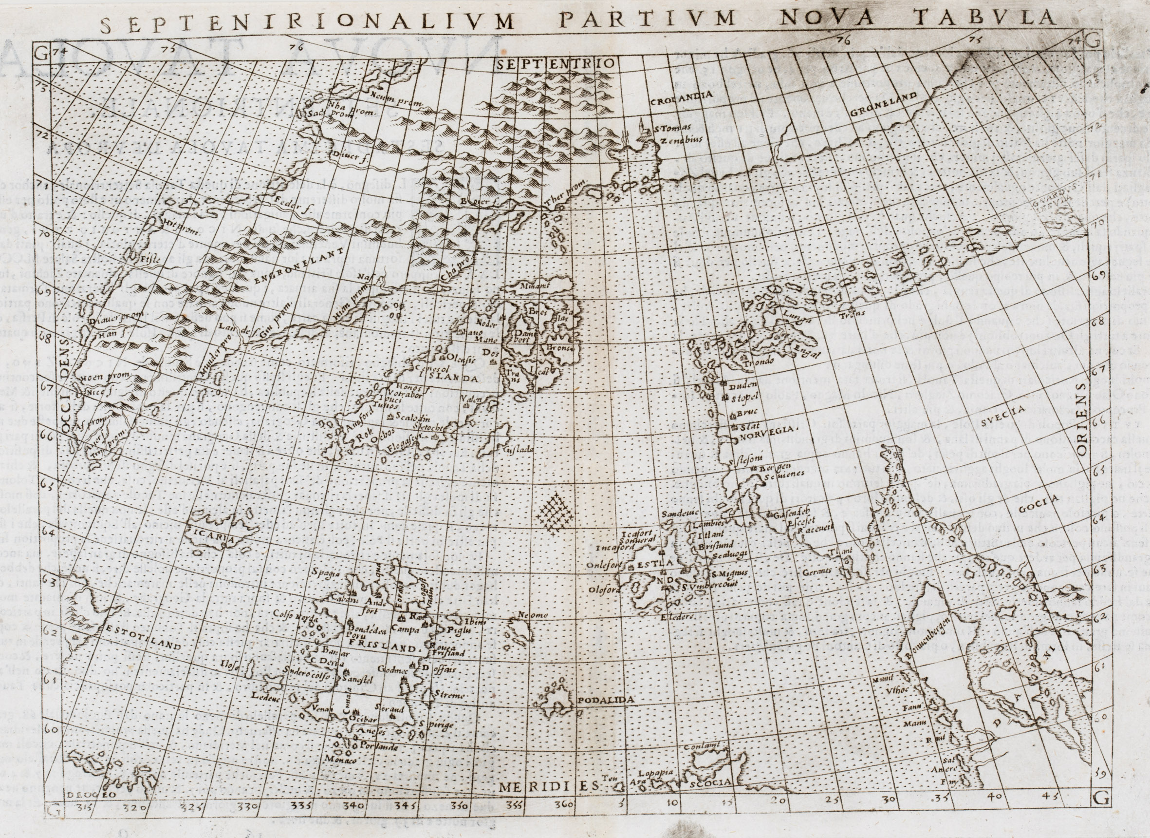
This Ruscelli map of 1574, like the one of 1561 (No. 75), is based on the so-called „Zeno map“, a woodcut map, titled „Carta Da Navegar De Nicolo et Antonio Zeni Furono in Tramontana Lano MCCCLXXX“ which was included in a book published by Francesco Marcolini in 1558. It describes the explorations of Nicolo and Antonia Zeno in the North Atlantic in the 1390s (see No. 150).
The Zeno map was re-engraved in reduced format for Ruscelli‘s 1561 Italian edition of Ptolemy‘s „Geographia“. The main correction was the removal of the land bridge from Scandinavia to Greenland and the replacement by a faint line.
There are two states of the Ruscelli map, both are in the „Schulte Collection“. The map of 1561 (No. 75) was printed from the first plate. This map (No. 157) is from a new plate which was introduced in 1574.
Apart from the faint line which is omitted in the 1574 version the changes between the two states are purely typographical. The title SEPTENTRIONALIUM and the place-name DROGEO (at the very lower left) in the 1561 version have become SEPTENIRIONALIUM and DEOGEO in the 1574 of the map.
This rare map covers the area from „Estotiland“ and „Deogeo“ in the west to Scandinavia in the east. Greenland is named „Septentrio“ (North) and divided into three parts: „Engroneland“, „Crolandia“ and „Groneland“. Surprising is the depiction of an erupting volcano next to a monastery named „S Tomas Zenobium“.
Iceland is depicted in a very strange shape stretching diagonally from southwest to northeast. Obviously it is taken from Olaus Magnus’ famous „Carta Marina“ of 1539 but „the mountains, rivers and all the pictures have gone and the ice flows off the east coast on Olaus‘ map have become islands“ (islandskort.is). There are five church symbols but only two can be allocated: „Scalodin“ to Skalholt and „Olensis“ to Holar.
Similar to the Zeno map (No. 150) and the first state of the Ruscelli map (No. 75), there are numerous mysterious islands in the North Atlantic that nobody had heard of at that time and which are depicted in remarkable detail: (from west to east) „Estotiland“, „Deogeo“, „Icaria“, „Frisland“ (with 32 place-names), „Grislada“, „Neome“, Podalida“ and „Estlanda“.
Centuries later geographers started investigations to retrace the Zeno brother‘ routes and to find out what is behind the names of the mysterious islands, which of them are existing in reality and which is their new name. It is now agreed that „Estotiland“ is Nova Scotia including Labrador, „Deogeo“ the Newfoundland region, „Estlanda“ the Shetland Islands and „Neome“ the Fair Isle or Foula. Obviously all the other islands may simply be an invention of the mapmaker(s). However, „Frisland“ appeared on maps as late as the 1675 world map of Nicolaas Visscher.
Many of these mythical islands were depicted on maps for centuries, mainly because the Zeno map (No. 150) was widely accepted at the time of publication and incorporated in the works of leading cartographers.
In the 19th century the Zeno account and map came under scrutiny. Most famously, Frederick W. Lucas questioned the validity of the voyage in „The Annals of the Voyages of the Brothers Nicolo and Antonio Zeno in the North Atlantic“ (1898). He accused Nicolo the younger of making the map up, using islands found on other maps and simply scattering them across the North Atlantic, and Nicolo on trying a Venetian claim to the New World that superseded the Genoan Christopher Columbus voyage.
Most modern historians regard the Zeno map and the accompanying narrative as a hoax, perpetrated by the Younger Nicolo to make a retroactive claim for Venice habing discovered the New World before Christopher Columbus.
Whatever the truth, the Ruscelli map with the „Zeno islands“ is an outstanding example of the fancy of early maps and travel literature.