
Johannes Janssonius (1588 – 1664)
(also known as Johann or Jan Jansson or Janszoon), born in Arnhem, was a Dutch cartographer and publisher who lived and worked in Amsterdam. Having met writers, mapmakers and engravers through his father, Jan eventually married Elisabeth de Hondt, the daughter of the renowned Jodocus Hondius the Elder. He produced his first maps in 1616 and established himself in Amsterdam next door to the bookshop of Willem Blaeu. In 1623Janssonius expanded to Frankfurt, later to seven other cities. In the 1630s Janssonius formed a partnership with his wife’s brother Henricus Hondius. Using the atlas plates developed by his father-in-law and Gerhard Mercator, adding his name, they published atlases as „Mercator-Hondius-Janssonius“. Under the leadership of Janssonius the Hondius Atlas was steadily enlarged. Renamed „Atlas Novus“, it had three volumes in 1638. Janssonius maps are similar the those of Willem Blaeu and led to accusations of plagiarism and theft of intellectual property, to which Blaeu reacted by using „Jan Zoon“ to sign his works. However, many of Janssonius’ maps predate those of Blaeu and/or covered different regions. In 1657, a fifth volume was added, the „Atlas Maritimus“, a significant sea-atlas. By 1660, at which point the atlas bore the appropriate name „Atlas Major“, there were 11 volumes, containing the work of more than 100 credited authors and engravers.
After Janssonius‘ death the publishing company was continued by his son-in-law Johannes van Waesbergen who combined the two surnames. „Janssonius Johannes van Waesbergen“ published a new rendering of Cloppenburg‘s „Atlas Minor“ under the title „Nieuwe en beknopte uytbeeldinge en Vertooninge der gantscher Aerdbodem“ in Amsterdam in 1673. Later Jansson‘s plates were acquired by Gerard Valck and Pieter Schenk who added their names and published them, largely unchanged, again between 1683 and 1696.
Map details
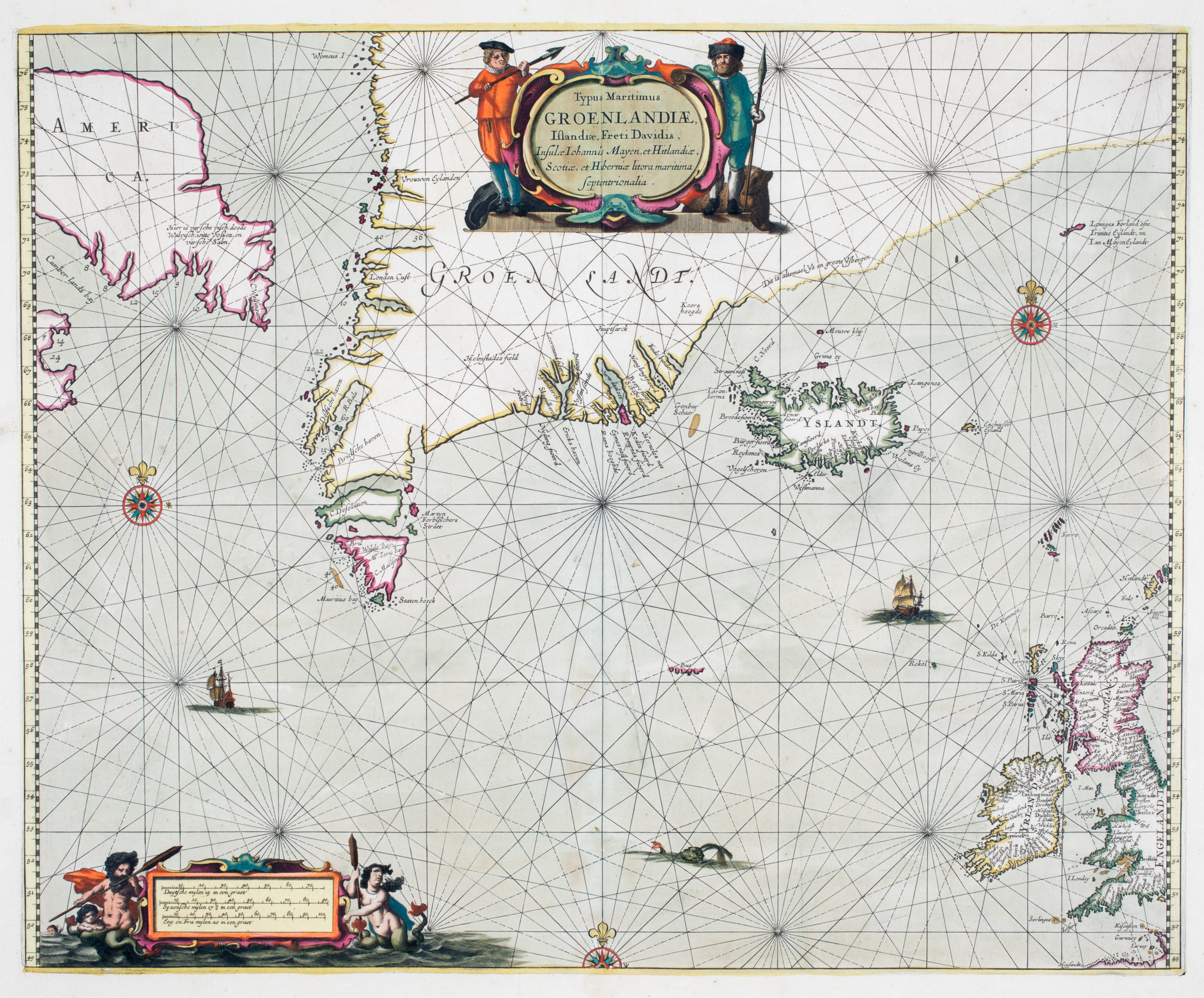
This decorative sea chart of the North Atlantic was included in the edition of 1657 or later of the „Atlas Novus“. It is embellished with a decorative title cartouche, flanked by whalers, in the upper center. In the lower left corner is an ornated bar with three mileage scales, guarded by mermaids. Rhumb lines radiate from decorated compass roses. Sea monsters ramble and ships sail the Arctic Ocean.
The maps covers the Davis Strait, Baffin Island („America“), the southern part of Greenland, Iceland, the Faroe Islands, Jan Mayen and the British Isles.
The place names along the coastlines represent encounters of European fishermen and whalers with the lands in the North Atlantic, as well as the explorations of those in search of the Northwest Passage, including John Davis (c 1550 – 1605), half-brother of Sir Walter Raleigh who led three voyages to the far north (1585, 1586, 1587), specifically to Greenland, Baffin Bay and Labrador. A note in the far northwest states: „Here is fresh fish, dead whales, white foxes and fresh salmon“.
To the Northeast, Greenland‘s coastline is only suggestive. The extent of the shore remained unknown at this time. Only the finding remains that the area
Originaltext „(is all ice and big mountains of ice)“.
The nearby Jan Mayen island was named by Willem Blaeu after Captain Jan Jacobszon May van Schellinkhout of the „Gouden Cath“, one of the ships that visited in 1614.
Along the coastline of Iceland there are many place names mainly of bays, fjords and harbours, bestowed by the Viking settlers and their descendants which have settled the country in the late ninth century, but also the name „Hola“ (one of the two bishoprics) and „Iokula“ (Icelandic for glacier). The interior of Iceland is completely empty.
Also two fantasy islands are depicted: „I. Gouberna“ near the Westfjords and „Enchuyser Eyland“ east of Iceland.
Sea charts have been very popular with mapmakers in the second half of the 17th century and quite a few look very similar. Of this type, the „Schulte Collection“ contains five maps in total. Besides the Janssonius maps of Johannes van Loon (No. 129) of 1666, Pieter Goos (No. 44) of 1669, Theunis Jacobsz (No. 61) of 1676 and Johannes van Keulen (No. 55) of 1681.
auch 159!