
Johannes van Keulen (1654 – 1715)
was a Dutch cartographer and publisher who mainly produced nautical charts and atlases, the founder of a firm which should become the biggest and most influential name in the history of Dutch sea-charts.
Born in Deventer, Johannes established himself in Amsterdam in 1678. In 1680 he gained a privilege from the States of Holland and West Friesland for the publication of pilot guides and sea atlases. In that year Johannes released the „Zee-Atlas.De groote nieuwe vermeerderde Zee-Atlas ofte Water-Wereld“ which became immensely popular and was steadily re-produced until 1734. In 1681 „De Nieuwe Groote Lichtende Zee-Fakkel“ (Shining Sea-Torch) appeared. The atlas had charts compiled by Claes Jansz. Vooght and artwork from Jan Luyken. This five-volume work was published in several editions until 1685 and made Johannes van Keulen famous. There were translations of the atlas in French, English, Spanish and Italian language.
Gerard van Keulen (1678 – 1726), the son of Johannes van Keulen, was endowed with talent and by doing an internship with his father, Gerard became a skillful engraver. He was also proficient in mathematics and navigation and established the scientific basis of the van Keulen firm. In 1714 he was appointed hydrographer to the Dutch East India Company and the family remained chart makers until the company‘s liquidation.
After Gerard van Keulen‘s death at the age of only 49 years, his son Johannes van Keulen II. (1704 – 1755) carried on the business. He is known in particular for his publication in 1753 of a sixth volume of the „Zee-Fakkel“ which contained new charts of the route to the East Indies and was re-printed until 1773.
When Johannes van Keulen the Younger died, his son Gerald Hulst van Keulen (1733 – 1801), great grandson of the founder of the „Empire“, took over the firm. He was responsible for publishing the final true van Keulen editions of the family‘s signature product, the „Zee-Fakkel“. When he died the business was continued by his son Johannes Hulst van Keulen and after his death in 1844 the firm passed out of family hands and flourished under different names until 1885.
Map details
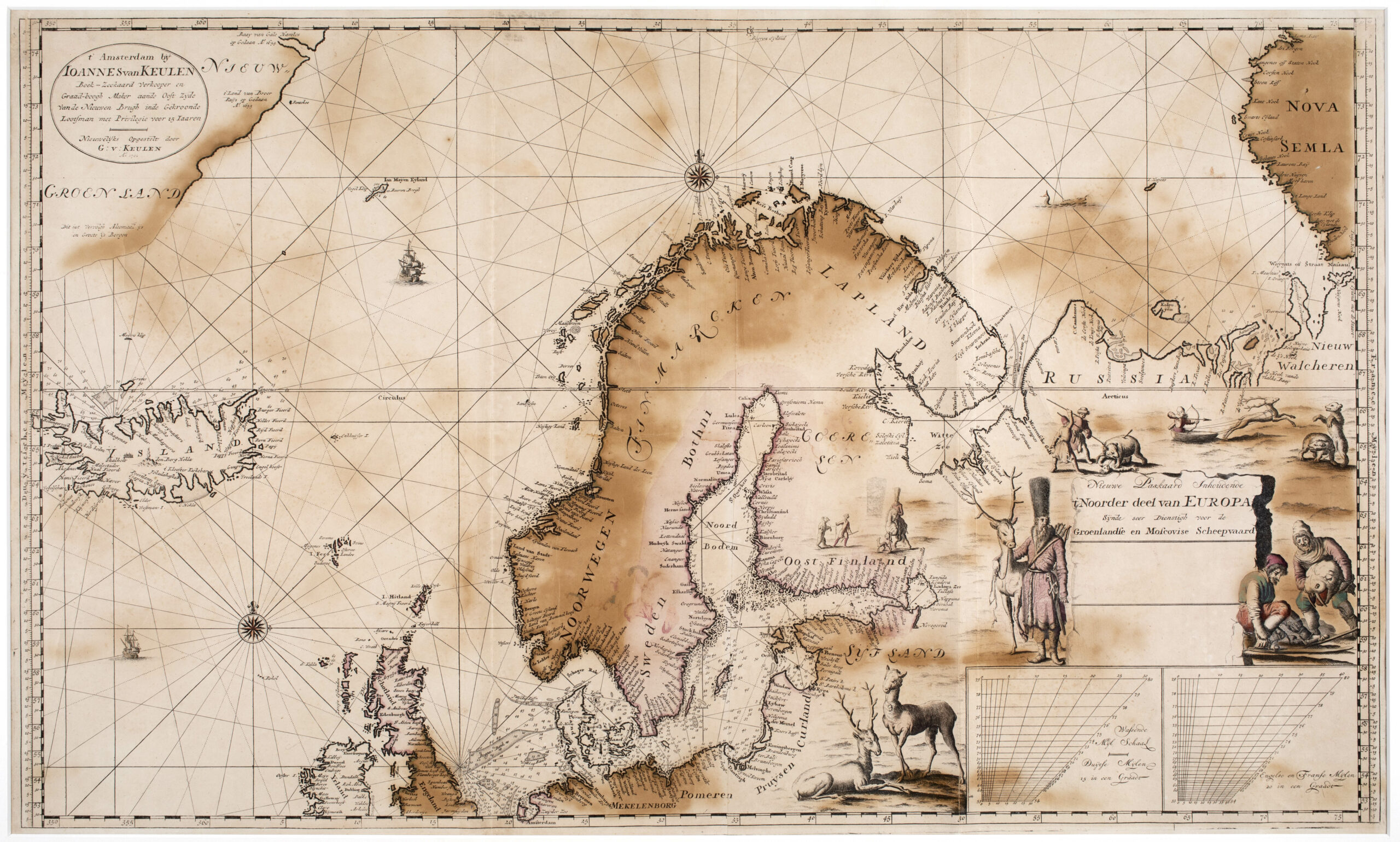
This very large early navigation chart is on Mercator‘s projection with increasing degrees of latitude. Variable ‚sliding’ graduation scales („checkerboards“) are given in the lower right corner, to compensate for the projection distortion at this latitude, both in nautical miles (15 in a degree) as well as English/French nautical miles (20 in a degree). The map shows many depth soundings in fathems, especially in the North Sea, the Baltic Sea, around Iceland and along the northern Russian arctic coasts.
The title cartouche is in the lower right corner with highly decorative hunting scenes.
The address cartouche in the upper left corner identifies Iohannes van Keulen as the bookseller and mapmaker and also mentions his son „G: v: Keulen“. The date 1701 is added. Two compass roses and rhumblines serve the navigation; two vessels are depicted for decoration.
The depiction of this beautiful map focusses on Scandinavia and the Baltic Region flanked by the east coast of „Nieuw Groenland“, „Ysland“ (Iceland) and „Ian Mayen Eyland“ in the Northwest, „Russia“, „Nieuw Walckeren“ and traces of „Nova Sembla“ in the East and the Faroe, Shetland and Orkney Islands, nearly whole Great Britain and Ireland in the Southeast and „Pomeren“ (Pomerania), „Pruysen“ (Prussia), „Curland“ and „Syjsand“ in the Southeast. With the exception of Greenland, the coastlines and regions are well outlined.
On the map of Iceland itself, numerous place names are to be found along the coastline. In the interior Hekla („den Berg Hekla“) is to be seen during an eruption.
The two bishoprics are depicted differently: Skalholt is marked with a huge cathedral, in contrast Holar („Halar“) is only written. Unusually for sea-charts,two glaciers are named.
COMMENTS BY THE ANTIQUARIAN
This map was offered at an internet auction by wellknown PAULUS SWAEN Old Maps & Prints in New York in November 2022. The description was as follows:
„A very large, exceptionally rare, early navigation chart of Scandinavia by van Keulen …
The chart was never included in regular atlases by van Keulen, probably because of its hugh size … , but rather sold as a loose navigation chart, particularly for whale hunting and for the trade with Archangelsk … Our example seems to be the only recorded first version of this important map that ever appeared on the market“.
In 2023 Leen Helmink Antique Maps offer a nearly identical map of 1722. The only difference is that the year 1701 is missing. „We have never before seen examples of this sea chart offered in the market“.
Their experts refer to a famous map historian Cornelis Koeman who mentions one with date 1701 in the first part of „De Nieuwe Groote Lichtende Zee-Fakkel“ of 1734.