
Aaron Arrowsmith (1750 – 1823)
was an English cartographer, engraver, publisher and founding member of the Arrowsmith cartographic family dynasty. Born in Winston, County Durham in 1750, without formal qualification he went to London for work around 1770. He may have trained with William Faden, Geographer to the King, but was certainly employed by John Cary in 1782, as he is credited with the survey work for „Cary‘s Actual Survey, of the Great Post Roads between London and Falmouth“, published in 1784 and also for „Cary‘s New and Correct English Atlas: being a set of county maps from actual surveys“ (1787). At this time Aaron Arrowsmith had already established his own business. Tooley characterized him as „easily the foremost cartographer of his time“ (Tooley), specializing in large-scale or multi-sheet maps. His first independent publication was his „Chart of the World on Mercator‘s Projection exhibiting all the New Discoveries to the present time: with the tracks of distinguished Navigators since the year 1700“, on eleven sheets, edited in 1790. In 1804, 63 maps were published in the „New and elegant General Atlas Comprising all Discoveries to the Present Time“. Later editions of the atlas were published in 1805, 1812 and 1819. In 1810 he became „Hydrographer to the Prince of Wales“ and in 1820 „Hydrographer to the King“.
Aaron Arrowsmith‘s maps have set a new standard: he was assiduous in analyzing and verifying his sources, also diligent in revising and improving his maps to keep them up to date and engraved in a clear and highly legible style.
After his death in 1823, the business passed to his sons Aaron Jr. (1802 – 1854) and Samuel (1805 – 1839) and then to his nephew John (1790 – 1873) who became a founding member of the „Royal Geographical Society“. After John‘s death, the majority of his stock was eventually bought by Edward Stanford who co-founded Stanfords Map Shop which is still open in Covent Garden, London today, according to their Website: „The World‘s Biggest and Best Map and Travel Shop“.
Map details
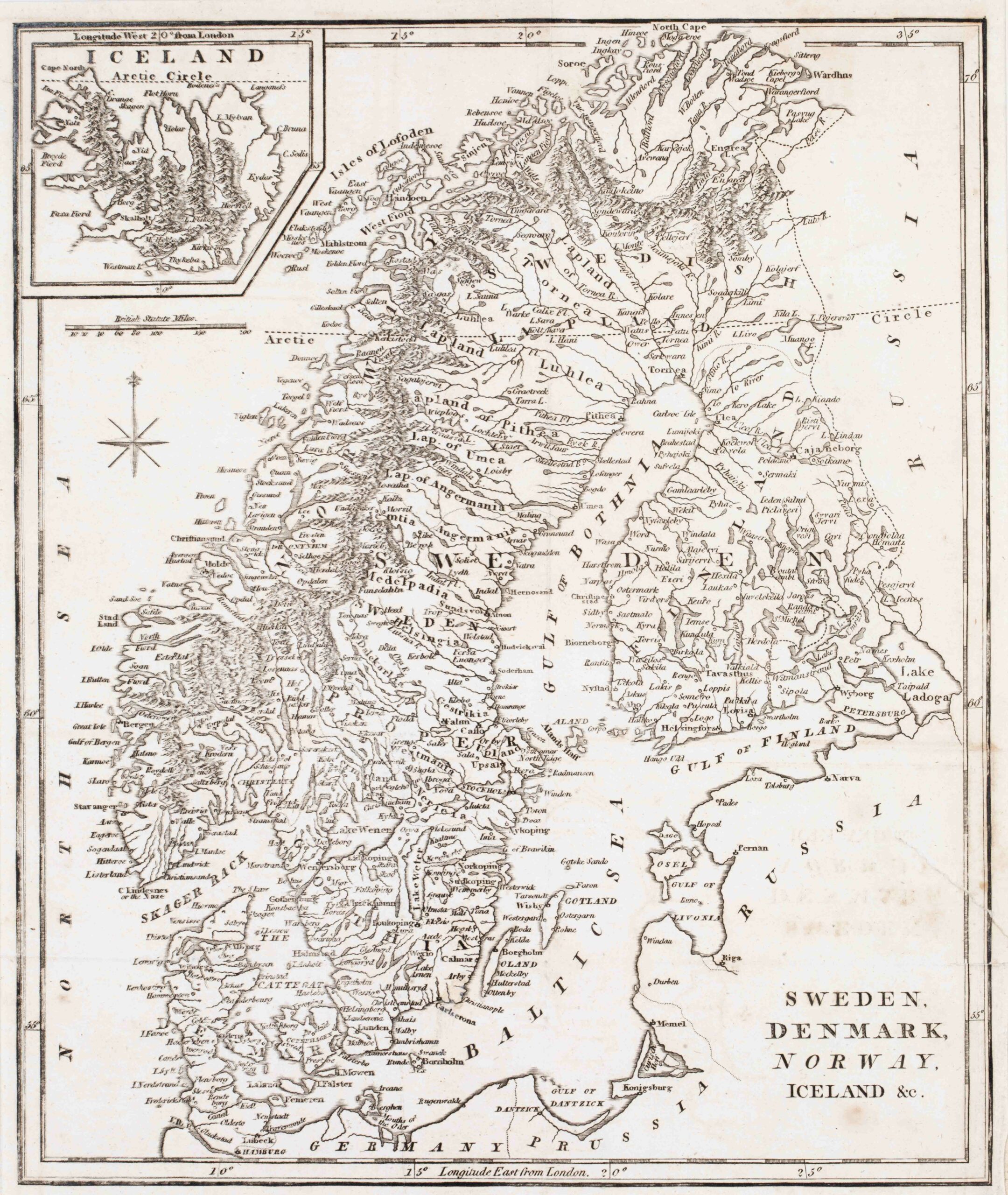
This map was published in the 1798 edition of Clement Cruttwell‘s Atlas „The New Universal Gazetteer; or, Geographical Dictionary …“ The title is placed in the lower right corner without any decoration. The map shows Scandinavia, the western part of „Russia“, „Prussia“, the northern part of „Germany“ and Iceland in a pentagonal inset in the upper left corner. Underneath are a compass rose and a distance scale.
In the inset „Iceland“ is written over the map which is dominated by long mountain ranges and contains only a few place names along the coastline and also in the interior, eg the bishoprics Skalholt and Holar and Mt. Hekla (all without symbols). The Arctic Circle is depicted in the main map and also in the inset but runs too far south in Iceland. In reality it crosses Grimsey and not the western fjords but the island is missing on the map.
In the „Schulte Collection“ there are four maps from four different authors which look (nearly) identical and the question is who has has created the original copper plate. One answer is given by the publication dates. The map of Wilkinson (No.164) dates 1794, the map of the anonymous author dates 1795, this map of Arrowsmith (No. 169) dates 1798 and the map of Cooke (No. 165) dates 1802. The other answer lies in the fact that Wilkinson‘s name and shop location are to be found on his map underneath the neatline and both informations have obviously been deleted by the other authors.
COMMENTS BY THE COLLECTOR
I found this map on Ebay in May 2023. It was offered by „Simon Simon“ in Eaglemont, Victoria, Australia. The address looked like the one of a private person. The mapmaker was named „Aaron Pfeilschmied“ which confused me because I did not know any mapmaker with this family name. My literature research finished without any result. Later, all of a sudden I realized that „Pfeilschmied“ is the German translation of „Arrowsmith“. There are more secrets. The year 1798 was specified as the publication year but I could not find a work of Aaron Arrowsmith which was edited in that year.
When I bought the map (for 49,98 US$) I discovered that Simon is the name of a proprietor of „Classical Images“, a well-known map shop. In the description I found the mystery solution. The map was published in the 1798 edition of Clement Crutwell‘s „Atlas to Crutwells Universal Gazatteer“, an enormous compilation, of which the entire edition was quickly sold out. In fact this Arrowsmith map is rather rare.