
Emanuel Bowen (1694 – 1767)
was map and print seller who worked in London from about 1714 where he produced some of the best and attractive maps of the 18th century. Bowen was engraver to both King George II of England and to Louis XV of France. One of his earliest engraved works „Britannia Depicta“, published in 1720 contained over two hundred road maps together with a miniature map of each of the counties of England and Wales. It was an unusual feature of the atlas that the maps were engraved on both sides of each page, and this resulted in a handier sized book. Other famous works are „A Complete System of Geography“ (1744 – 1447), „The Large English Atlas“ with Thomas Kitchin and „Atlas Minimus“ with John Gibson. Despite of his renown and success Emanuel Bowen died in poverty, like many cartographers. His cartographical work was taken over by his son Thomas who suffered the same fate.
Map details
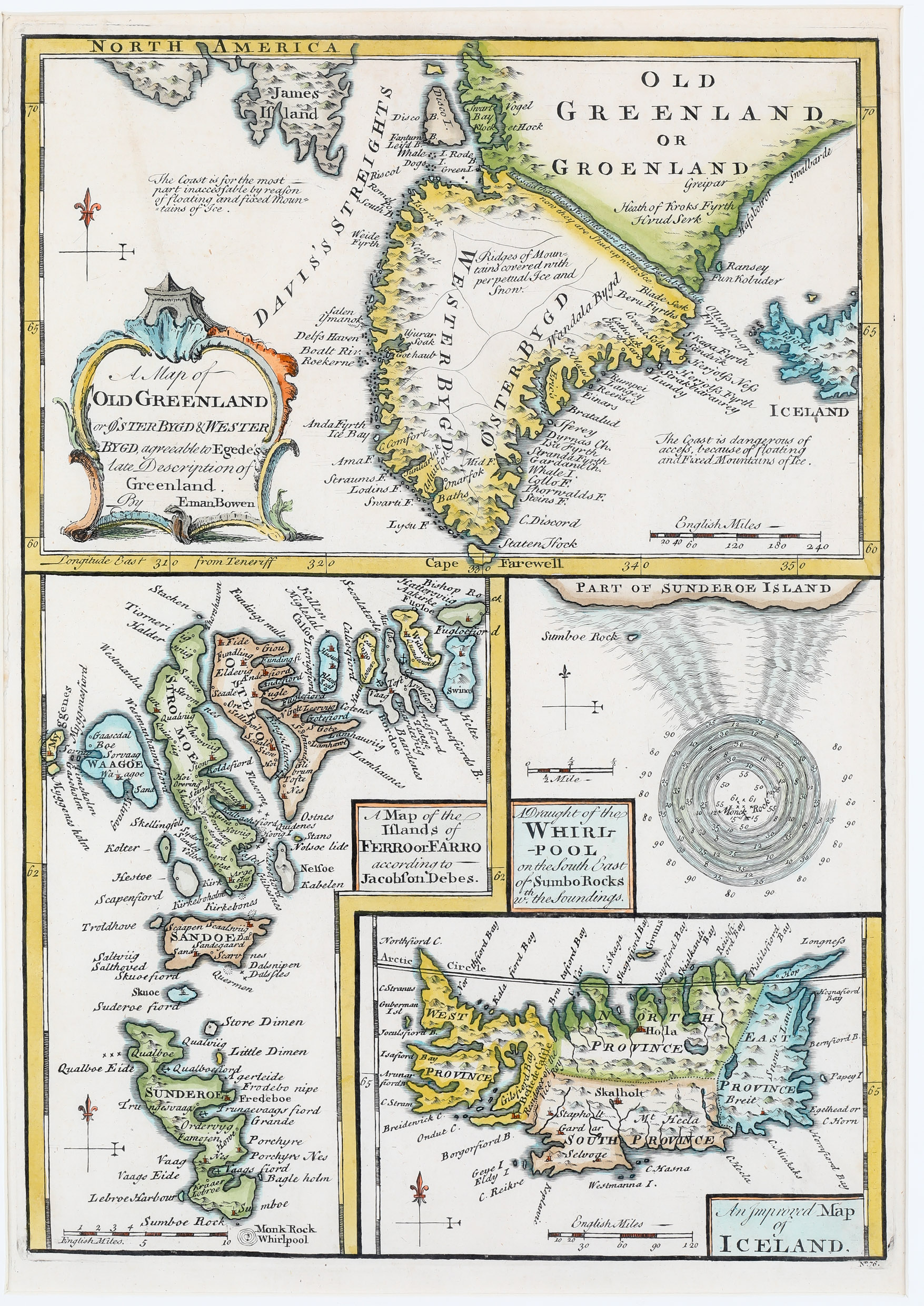
A Map of Old Greenland or Oyster Bygd & Wester Bygd, agreeable to Egede‘s late Description of Greenland. A Map of the Islands of Ferro or Farro according to Jacobson Debes. A Draught of the Whirlpool on the South East of Sumbo Rocks with the Soundings. An Improved Map of Iceland.
An unusual engraving from Bowen‘s „A Complete System of Geography“. The sheet is a composition of three maps (Greenland, the Faroe Islands and Iceland) and a Whirlpool.
When this map was drawn the coasts of Greenland were fairly well mapped out by Icelandic and Scandinavian whalers. Bowen notes that access to the coast of Iceland is dangerous because of „Floating and Fixed Mountains of Ice“.
The Faroe Islands have been historically treacherous for mariners due to the unpredictable currents and tides surrounding them. of which the great „Maelstrom“ which roared at the tip of the southeast island of Suduroy is the most curious and legendary. This mighty whirlpool swirled around a sheer pinnacle of a rock called Monek which was said to resemble a monk from one side and a sailing ship. According to reports the whirlpool was over a mile in diameter. Soundings show that the waters around had a depth of some 80 to 90 fathoms (146 to 165 meters) but that the waters nearer to the rock, at the center of the Maelstrom, were about 7 to 10 fathoms (13 to 18 meters) deep. Sadly this startling natural phenomenon is no more. In 1884 much of Monek rock crumbled into the sea, creating a dangerous underwater reef and displacing the unique convergence which created the Maelstrom.
The „Improved Map of Iceland“ is a copy of Iceland as it appears on Herman Moll’s map of 1739 who again got his ideas from Joris Carolus‘ map of c. 1630. The place-names are nearly the same; the only „improvement“ is that three are missing.