
Jacques-Nicolas Bellin (1703 – 1772)
Jacques-Nicholas Bellin was a French hydrographer, geographer and member of the intellectual group „Philosophes“. Born in Paris, at the age of 18 years, he was appointed hydrographer to the French Navy. In 1741 Bellin became the first „Ingenieur de la Marine“ of the „Depot des Cartes et Plants de la Marine“ (French Hydrographical Office) and was named „Hydrographe Officiel du Roy de France“. During his reign the Depot published a prodigious number of maps and atlases, e.g. the „Atlas Maritime“ (1764) and the „Petit Atlas Maritime“ (1764). Bellin also contributed a number of maps to the „Histoire Generale des Voyages“ of Antoine Francois Prevost d‘Exiles (1697 – 1763), a French author and novelist (e.g. „Manon Lescaut“), simply known as „l‘Abbe Prevost“. Prevost‘s collection was printed for the first time in 1746 and it continued until 1789, more than 20 years after his death. Many of Bellin‘s maps were copied by other mapmakers.
Bellin‘s work focussed on function and accuracy, tending to be less decorative than the 17th century cartographic images, thus gaining for France the leading role in European cartography in the 18th century.
Map details
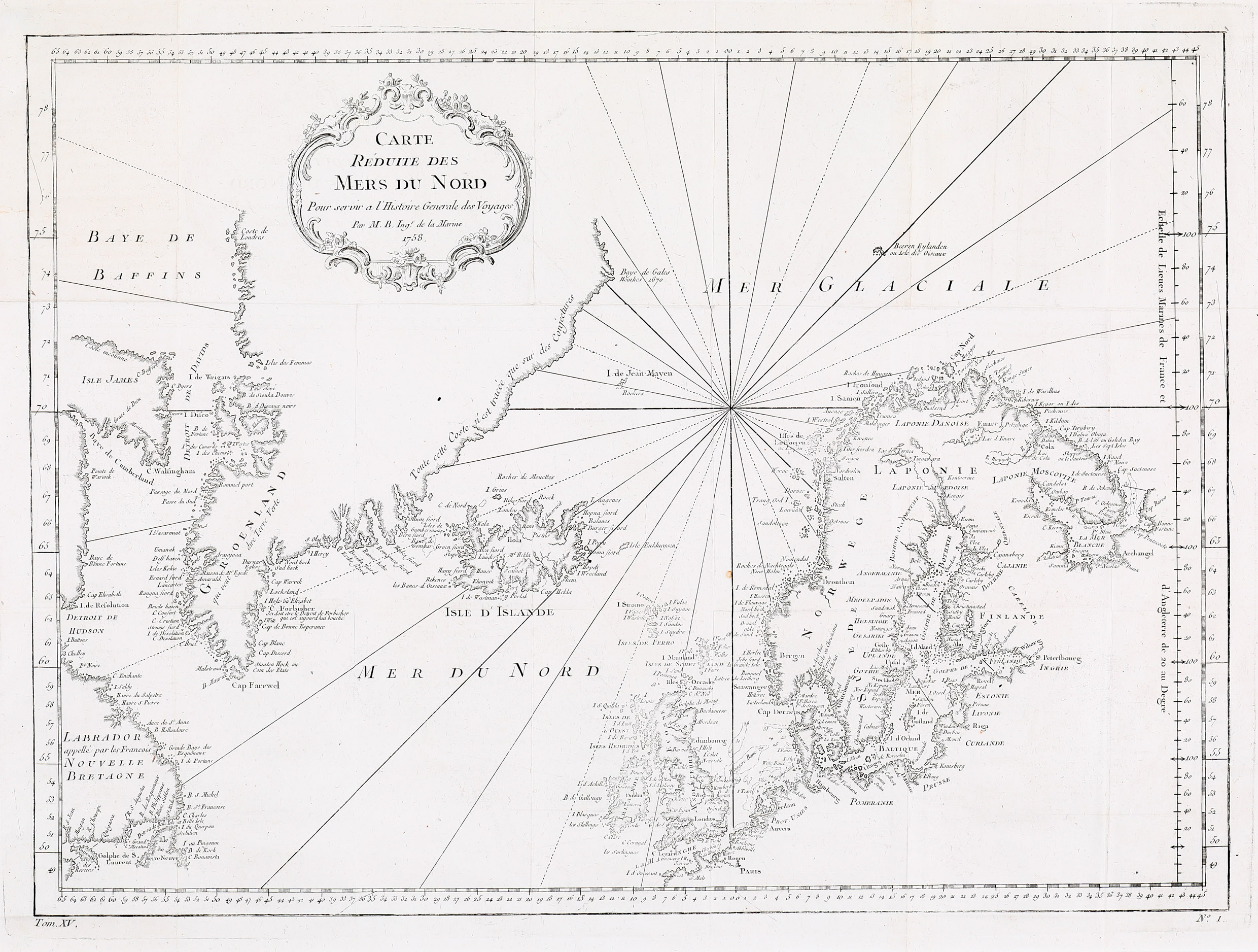
This sea-chart first appeared in Antoine Francois Prevost‘s „Histoire Generale des Voyages“ in 1758 and again in Jean-Francois La Harpe‘s „Abrege de l’histoire generale des voyages“ in 1780.
The map is decorated with a nice title cartouche in the upper part, a compass rose nearly in the center and rhumblines. It gives an excellent overview of the North Atlantic and depicts Iceland, the southern part of Greenland, Baffin Island („Isle James“)and „Labrador appelle par les Francais Nouvelle Bretagne“ in eastern Canada, the coasts of Scandinavia, the Baltic Region and the British Isles. The map is well engraved and detailed but not accurate in parts, for instance Greenland. the coast stretches too far south and the eastern coastline runs wrongly as the author admits: „Toute cette Cost n’est traccee que sur des Conjectures“ (drawn only on speculation“.). Frisland is not to be seen but the fictitious „Isles de Gumbermans“ on the west coast of Iceland are depicted. European capitals such as Paris, Amsterdam, London, Dublin, St. Petersburg, Stockholm and Oslo are labelled, along with numerous smaller cities.
Iceland itself looks rather disproportionate and unlike on other maps done by Bellin at the time. One explanation could be that this part of the maps origins before Niels Horrebow published the new shape of Iceland in 1752. Most information is coastal. In the interior of Iceland only the bishoprics Skalholt and Holar and Mt. Hekla are labelled.