
Jean Rene Antoine Verdun de la Crenne (1741 – 1808)
served as officer for the French Depot de la Marine. In the years 1771-1772 the French Government sent a scientfic expedition to the North Atlantic led by Verdun de la Crenne. He was accompanied by astronomer Alexander Pingre and Jean-Charles Borda and painter Pierre Ozanne. Their commission was to explore the ocean, the coasts, and the islands on their route. They were to correct errors on existing charts and test various ways of measuring latitude and longitude. As they only spent three weeks in a rather small area in the Westfjords of Iceland the results of this expedition were dubious but were the basis of the representation of Iceland on the French chart of the North Atlantic. The chart in general is much less accurate than those already in existence.
Map details
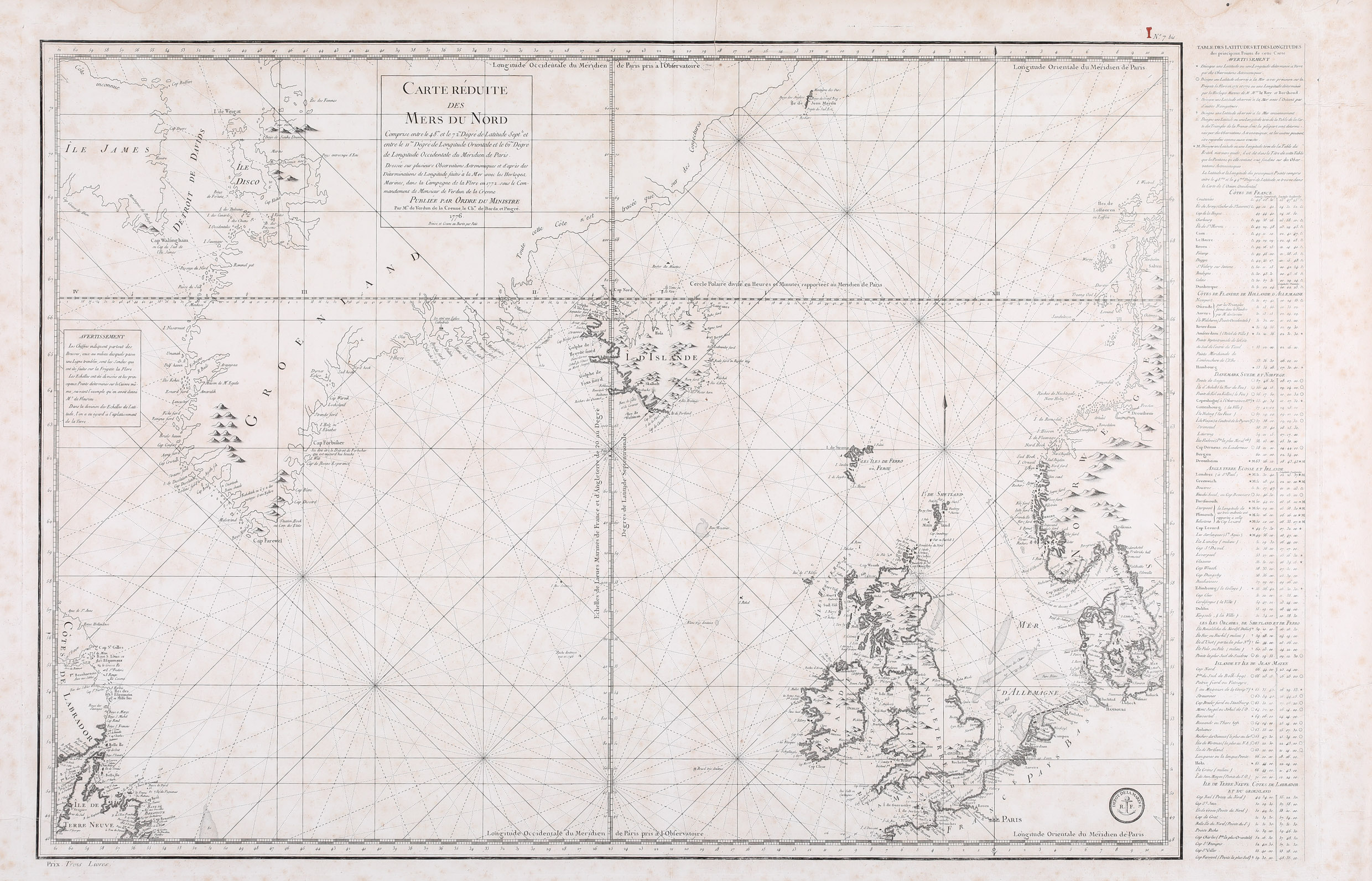
This finely engraved and detailed sea-chart of the North Atlantic and the North Sea extends from the coast of Labrador, Newfoundland and Baffin Island („Isle James“) in the west to the coastline of Norway and Sweden, including most of Greenland, Iceland, Great Britain, Denmark, parts of France and Germany. The title cartouche is to be found within a frame in Greenland, mentioning also Verdun de la Crenne’s voyage, the year 1776 and underneath the name of Petit, the engraver. On the left in the center of the map there is a legend concerning the wind and a table in the right-hand side margin lists the major locations locations with their longitude and latitude. In the chart a very precise technique was used by which only those coastlines definitely known are fully shaded, those inaccessible due to ice, or unchartered are sketchily defined. The map is decorated with fleur-de-lis, rhumb lines and three fine galleons.
Iceland itself looks strange, as if east and west pressed together, with the north gone up and the south down, the country having lost about half of its area. In the interior „I. D’Islande“ is printed. Some mountains including a spouting volcano in the south (not named but surely Hekla) are depicted and there are only two place-names, the bishoprics Skalholt and Holar. Astonishingly the Arctic Circle is nearly drawn correctly but Grimsey and the northernmost tip of the Westfjords are too much north.
The map of Bellin of 1776 with the same title looks identical but its size is larger.
Map details
This finely engraved and detailed sea-chart of the North Atlantic and the North Sea extends from the coast of Labrador, Newfoundland and Baffin Island („Isle James“) in the west to the coastline of Norway and Sweden, including most of Greenland, Iceland, Great Britain, Denmark, parts of France and Germany. The title cartouche is to be found within a frame in Greenland, mentioning also Verdun de la Crenne’s voyage, the year 1776 and underneath the name of Petit, the engraver. On the left in the center of the map there is a legend concerning the wind and a table in the right-hand side margin lists the major locations locations with their longitude and latitude. In the chart a very precise technique was used by which only those coastlines definitely known are fully shaded, those inaccessible due to ice, or unchartered are sketchily defined. The map is decorated with fleur-de-lis, rhumb lines and three fine galleons.
Iceland itself looks strange, as if east and west pressed together, with the north gone up and the south down, the country having lost about half of its area. In the interior „I. D’Islande“ is printed. Some mountains including a spouting volcano in the south (not named but surely Hekla) are depicted and there are only two place-names, the bishoprics Skalholt and Holar. Astonishingly the Arctic Circle is nearly drawn correctly but Grimsey and the northernmost tip of the Westfjords are too much north.
The map of Bellin of 1776 with the same title looks identical but its size is larger.
Comments by the collector
This map has been described by several prominent authors in the literature and therefore I am totally convinced that it is correctly credited to Verdun de la Crenne. However, it appears extraordinary to me that Bellin who had always used the Knoff-type of mapping Iceland has produced a map of the North Atlantic with this strange-shaped Iceland in the same year Verdun de la Crenne published his map. I have bought the Bellin map from Jonathan Potter Antique Maps, one of THE map experts worldwide and he has certified that the map he sold to me is from Bellin. I trust him but could not find any explanation for this „mystery“.