
Giovanni Francesco Camocio (1501 – 1575)
was an important early engraver and publisher. He registered his publishing activity in Venice in 1552 where he was the owner of the bookshop „Al segno della Piramide“ (At the sign of the Pyramid) at San Lio in Merceria, the main sale place for prints.
He was not only a seller of geographical maps but also of works of famous painters Titian and Michelangelo. In 1567 the Senate granted him the privilege covering devonianal subjects, portraits and maps.
Camocio was one of a group of 16th century mapmakers often referred to as „Lafreri School“, named after the Roman mapmaker and publisher Antonio Lafreri (1512 – 1577). Associated with Lafreri maps are among others Giacomo Gastaldi and Ferando Berteli of whom maps are in the „Schulte Collection“. Normally maps were issued loose but Lafreri assembled his large stock of maps (about 660), made by engravers both from Rome and Venice into composite atlases. Customers could order specific maps to be bound together, tailored to the needs or tastes of individuals. As a consequence the contents of the few atlases which have survived differ from one another. „Although the whole production of the so-called Lafreri maps must have been fairly substantial, most are uncommon if not scarce today“ (Ginsberg p. 70). The Lafreri School maps are regarded the earliest obtainable maps of various regions of the world.
Map details
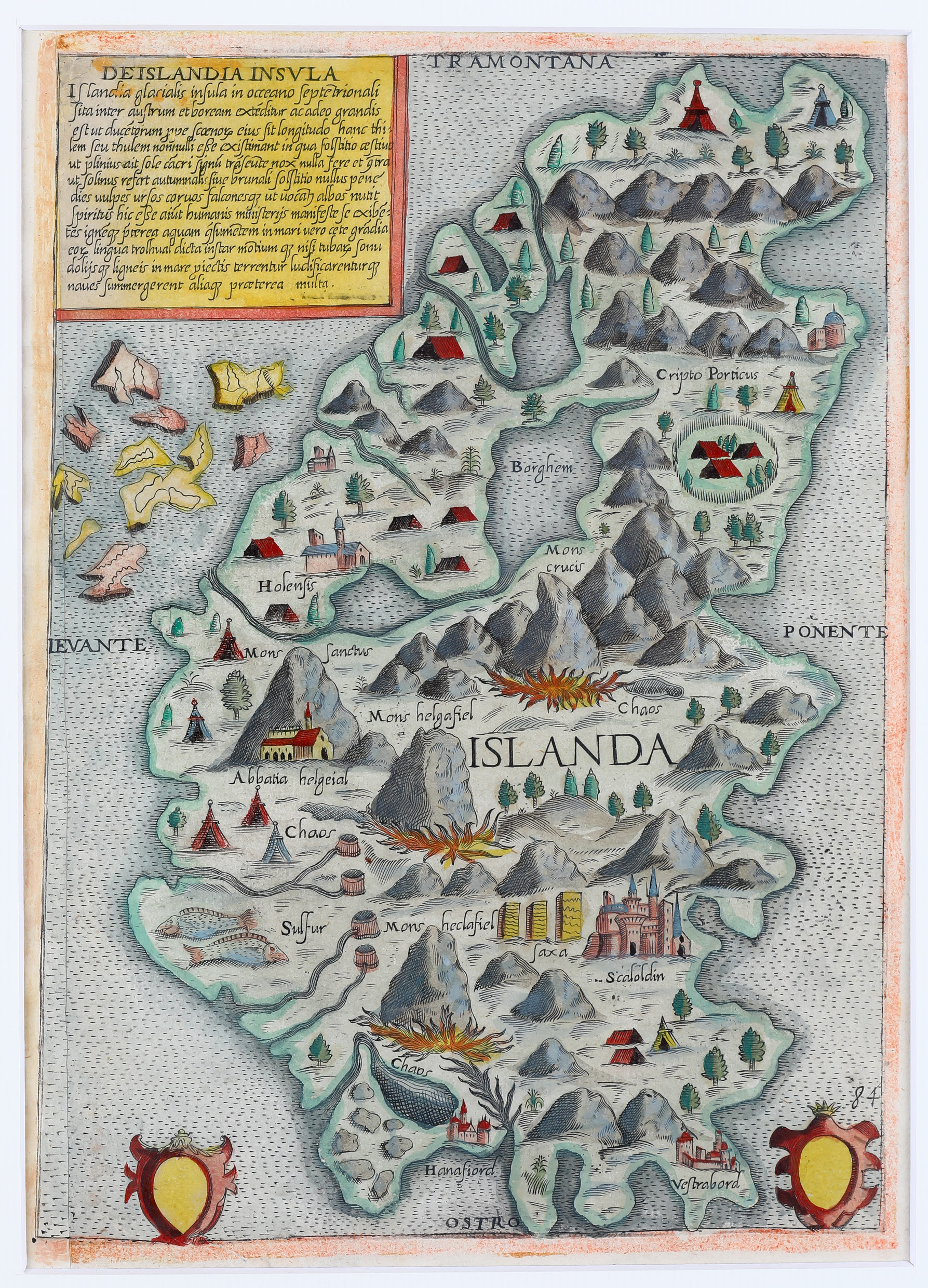
This very rare map is most likely from a volume of island maps which was published without title between 1566 and 1574, since 1575 known as „Isola Famose Porti, Fortezze E Terre Maritime“ by Donato Berteli who published the maps under his own name after Camocio‘s death.
Iceland is drawn as it appears on Olaus Magnus‘ „Carta Marina“ in 1539. The title cartouche in the upper the upper part („Tramontana“) gives explanations in Latin. In the lower part („Mezzodi“) there are two decorative vignettes in the left and right corner which are blank. In the middle of the map „Islanda“ is written. Like in Berteli‘s earlier map of 1566 east and west are unexplicably reversed. Information on degrees and scale is not given.
In the interior of Iceland some settlements are named including the two bishoprics.
„Scaloldin“ (Skalholt) is characterized by a big church which looks like an Italian cathedral, „Holensis“ (Holar) by a smaller church. Other churches are connected with with the names „Abbatia Helgeial“ and „Hanafiord“. „Vestrabord“ looks like a fortress.
There are four mountains („Mons“): Crucis, Sanctus, Helgafiel and Heclafiel of which „Helgafiel“ and „Heclafiel“ (the famous volcano Hekla) are highlighted by a big fire
and described as „Caos“. „Sulfur“ most likely stands for sulphur springs (but why are two fish depicted next to them?). Other names are „Saxa“ and „Cripto Porticus“.
At first glimpse this map and Berteli’s map of 1566 look identical but there are quite a few differences in detail. The size of this map is reduced because the edges are smaller. In the ocean around Iceland the sea monster and the sailing vessels have been omitted. The title cartouche in the upper left corner has the same text but Berteli‘s name and the year of publication have been deleted. The vignettes in the lower part are empty, „Ostro“ replaces „Mezzodi“ and „84“ is written next to the vignette one. (This change was made in 1574/75 according to the literature.)