
Johannes Cloppenburg (1592 – 1652) & Pieter van den Keere (1571 – 1646) & Johannes Janssonius (1588 – 1664) & Johannes van Waesberge (1616 – 1680)
Johannes Cloppenburg was a Dutch cartographer active in Amsterdam during the early 17th century. He is a somewhat elusive figure of whom little is known. In 1630 he published an edition of Mercator‘s small format „Atlas Minor“ with French text. Most of the maps have been engraved again in larger format by Petrus Kaerius.
Petrus Kaerius (the latinized version of his Dutch name Pieter van den Keere) was an engraver, publisher and globe maker. Born in Ghent, he emigrated in 1583/84 with his family for religious reasons to London. Three years later his sister Colette married Jodocus Hondius the Elder and from him Pieter van den Keere received training as an engraver. In 1593 both settled in Amsterdam where Pieter worked with different cartographers.
Johannes Janssonius (in English also Jan Jansson), born in Arnhem, was a Dutch cartographer and publisher who lived and worked in Amsterdam. In 1612 he married Elisabeth de Hondt, the daughter of Jodocus Hondius the Elder. He produced his first maps in 1623 and founded a bookstore in Frankfurt, later in seven other cities. In the 1630s Janssonius formed a partnership with his brother-in-law Henricus Hondius and together they published atlases as „Mercator-Hondius-Janssonius“. After Janssonius’ death the publishing company was continued by his son-in-law Johannes van Waesbergen who combined the two surnames. „Janssonius Johannes van Waesbergen“ published a new rendering of Cloppenburg‘s „Atlas Minor“ under the title „Nieuwe en beknopte uytbeeldinge en Vertooninge der gantscher Aerdbodem“ in Amsterdam in 1673.
Map details
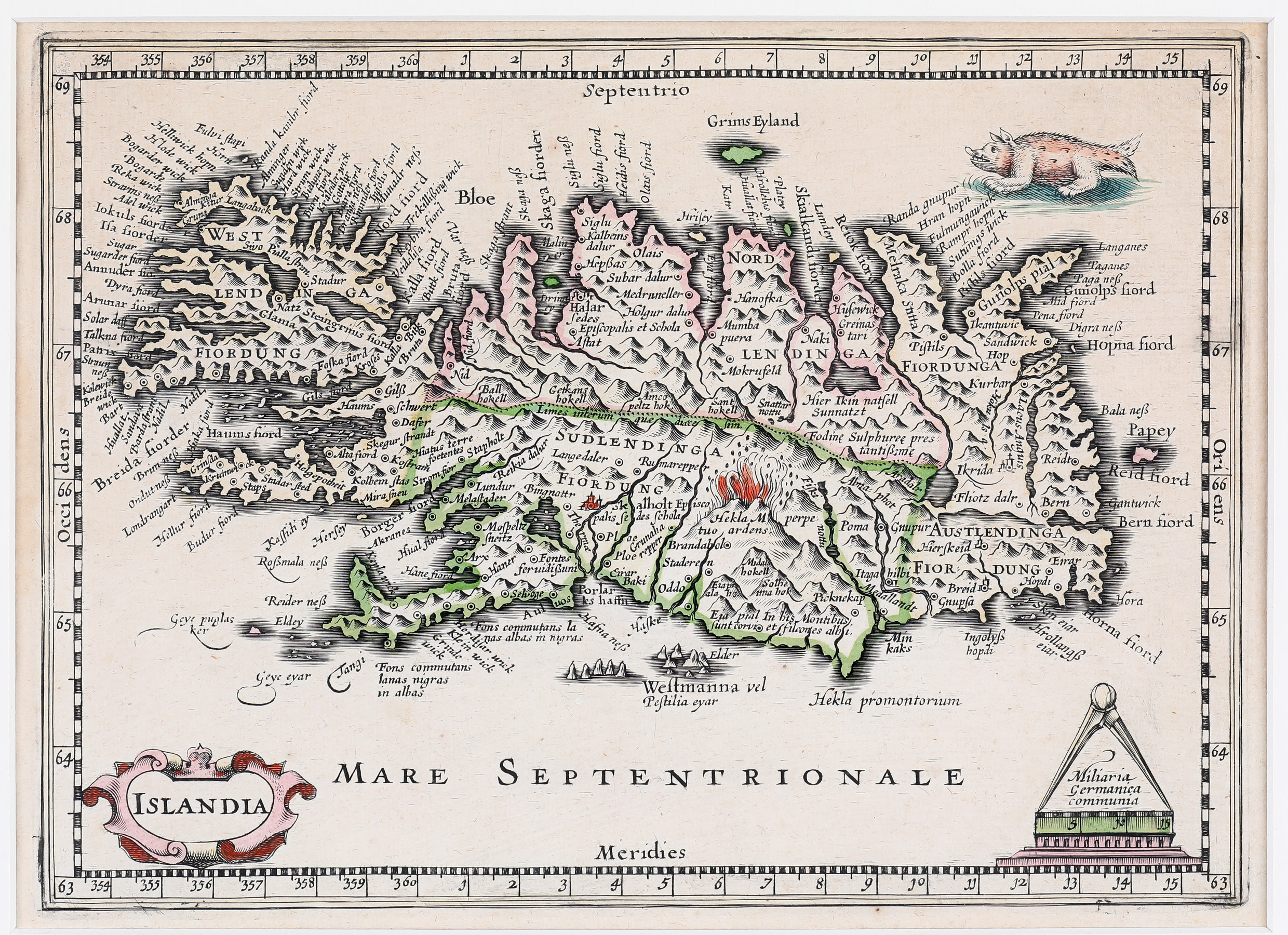
This map is a reduced and rather accurate version of Mercator’s large map of Iceland of 1595 and has accompanied the Janssonius Johannes van Waesbergen 1973 edition of Mercator‘s „Atlas minor“ which was taken from Cloppenburg‘s 1936 edition. It is engraved by Petrus Kaerius.
A strapwork cartouche in the bottom left quadrant contains the title. Another decorative cartouche in the opposite corner includes a distance scale with a circle and a sea monster at the top right completes the composition. The map is rather accurate and features numerous settlements, lakes, rivers, glaciers, fjords and mountains (223 (!) according to mappingiceland.is). Both bishoprics are (differently) described:
„Skalholt Episcopalis Sedes Schola“ and „Halar Sedes Episcopalis et Schola Astat“.
The famous volcano is shown in a fiery eruption with de text: „Hekla M perpetuo ardens“.
This map is nearly identical with the Cloppenburg-Kaerius map of 1630 but there are two differences: in that map the ocean is illustrated with waves and the engraver did place his name „P. Kaerius caelavit“ in the upper right corner.