
Johannes van Keulen (1654 – 1715) & Gerard van Keulen (1678 -1726)
Johannes van Keulen was a Dutch cartographer and publisher who mainly produced nautical charts and atlases. He was the founder of a firm which should become the biggest and most influential name in the history of Dutch sea-charts. Born in Deventer, Johannes established himself in Amsterdam in 1678. In 1680 he gained a privilege from the states of Holland and West Friesland for the publication of pilot guides and sea atlases. In that year Johannes released the „Zee-Atlas. De groote nieuwe vermeerderde Zee-Atlas ofte Water-Wereld“ which became immensely popular and was steadily re-produced until 1734. In 1681 „De Nieuwe Groote Ligtende Zee-Fakkel“ (Shining Sea-Torch) appeared. The atlas had charts compiled by Claes Jansz. Vooght and artwork from Jan Luyken. This five-volume work was published in several editions until 1685 and made Johannes van Keulen famous. There were translations of the atlas in French, English, Spanish and Italian language.
Gerard van Keulen, the son of Johannes van Keulen, was endowed with talent and by doing an internship with his father, Gerard became a skillful engraver. He was also proficient in mathematics and navigation and established the scientific basis of the van Keulen firm. In 1714 he was appointed hydrographer to the Dutch East India Company and the family remained chart makers until the company‘s liquidation.
After Gerard van Keulen’s death at the age of only 49 years, his son Johannes II. van Keulen (1704 – 1755) carried on the business. He is known in particular for his publication in 1753 of a sixth volume of the „Zee-Fakkel“ which contained new charts of the route to the East Indies and was re-printed until 1773.
When Johannes van Keulen the Younger died, his son Gerald Hulst van Keulen (1733 – 1801), great grandson of the founder of the „Empire“ took over the firm. He was responsible for publishing the final true van Keulen editions of the family‘s signature product, the „Zee-Fakkel“. When he died the business was continued by his son Johannes Hulst van Keulen and after his death in 1844 the firm passed out of family hands and flourished under different names until 1885.
Map details
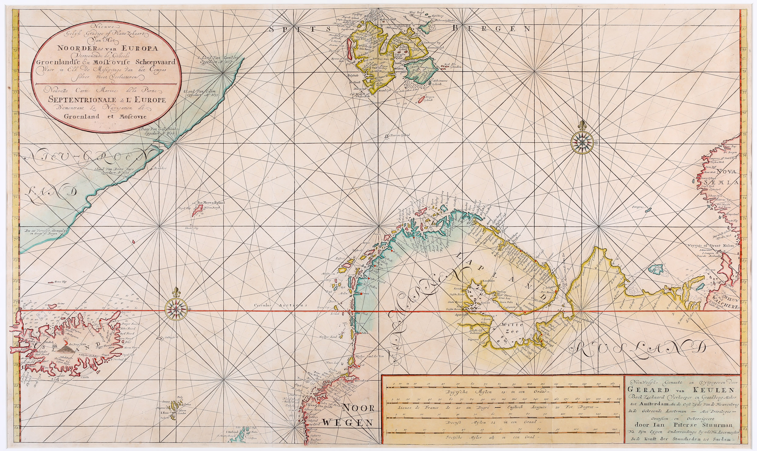
Nieuwe Gelyk Gradige of Platte Zekaart Van Het Noorder deel van Europa Vertoonende de Geheele Groenlandse En Moskovise Scheepvaard Waer in Elk de Miswysinge Van het Compas selver moet Verbeeteren (in short form repeated in French)
The origin of this impressive sea chart is not easy to figure out. In the title cartouche in the upper left corner at the end of the text there are four numbers which look like a year specifcation. „709“ is easy to identify but what is printed before is unclear. It can be read as „1“ which connected means „1709“. Consequently the seller of this map has interpreted this number as the publication year. According to de Vries the map was added in a 1709 addition of the first part of the „Zee-Fakkel“, titled „De Nieuwe Groote Ligtende Zee-Fakkel ´t Eerste Deel …“ However, in the literature other authors assign the map to an edition of the „Zee-Fakkel“ in 1734 or years in between. The strange thing about it is that on all these copies of the map the curious „1709“ can be discovered.
This large sea chart is double-page engraved on two joined sheets, folded twice. It is decorated with an oval title cartouche in the upper left corner in Dutch and French language. There are two rectangles in the lower right corner: one contains four distance scales and the second gives information on the author as whom Gerald van Keulen is named. Rhumb lines are intersecting two compass roses.
The map of the Arctic Ocean shows Greenland, Iceland, Spitsbergen, „Nova Semla“, „Rusland“ and northern Scandinavia, including the smaller islands Jan Mayen, „Beeren Eyland“, the Faroe Islands and the northernmost tip of the Shetland Islands („Hitlandt“). As it is a sea chart, not only the coastlines are depicted precisely but also soundings, shoales, anchorages and navigational hazards. Only the coastline of Greenland is largely blank, except for a few notations of explorer‘s discoveries. For such a small-scale map, the level of detail is excellent. It even includes the „Maalstroom“, the infamous whirlpool in the Lofoten archipelago of the Norwegian coast.
The interior of Iceland includes some place-names. The bishopric Skalholt is characterized by a big church, while Holar, the other bishopric, is only named („Halar“). Hekla is to be seen in a fiery explosion. The Arctic Circle runs only a little too far south.
Comments by the collector
„Spectacular and rare. An exceptional piece“