
Petrus Bertius (1565 – 1629) & Jodocus Hondius Jr. (1593 – 1629)
Petrus Bertius, the latinized version of his Dutch name Pieter de Bert, was a philosopher, theologian, historian, geographer and cartographer. Born in Beveren, Flanders he settled as a refugee in Amsterdam and after finishing his studies he became Professor of Mathematics and librarian at Leiden University. In 1618, he was appointed Cosmographer and Historiographer of Louis XIII of France. He was connected by marriage to Jodocus Hondius Jr. and Pieter van den Keere, his brothers-in-law and both cartographers, and this would influence his later life.
Jodocus Hondius Jr. was a Flemish engraver, cartographer and publisher. He took over the name from his father who used the latinized version of his Dutch name Joost de Hondt. To distinguish both, they are called „Sr.“ or „Elder“ and „Jr.“ or „ II“ respectively in the literature.
Jodocus Hondius the Elder (1553 – 1612) was one of the notable figures in the Golden Age of Dutch cartography (c. 1570s – 1670s). He grew up in Ghent and already in his early years established himself as an engraver, instrument maker and globe maker.
To escape religious difficulties in Flanders, he moved to London in 1584 where he married Colette van den Keere three years later und collaborated with her brother Pieter, also a mapmaker and engraver. In 1593 Hondius moved to Amsterdam. In 1604 he purchased the plates of Gerardus Mercator‘s famous „Atlas“ and republished it with additional maps. Though he used more and more his own plates he gave Mercator full credit as the author of the work, listing himself as a publisher. As the small Atlas „Epitome“, published by Ortelius became a big success there was an economical need to produce an easier to handle and cheaper version of the Mercator atlas. Therefore Hondius created the „Atlas Minor“ which was first published in 1607. The plates were later used – with different headings – by Samuel Purchas/Henry Featherstone in 1625 and Michael Sparke/Samuel Cartwright in 1635.
After the death of Jodocus Hondius the Elder, his widow Colette, with seven underage children, carried on running the publishing house using the signboard „de wackere Hond“ (the watching dog). In 1619 she passed the business to their sons, Henricus (1587 – 1638) and Jodocus Jr. (1593 – 1639). Following his father‘s footsteps Jodocus Hondius the Younger immediately began to publish under his own name, before opening his own business in „op den Dam“ (Dam Square) in 1621 .Even after going separate ways the brothers jointly owned the copper plates for their father‘s globe which they continued publishing together until after 1627. In 1629 Jodocus Hondius II. set out to publish his own atlas, featuring maps that were not included in the Mercator-Hondius Atlas. This new atlas was in direct competition with his father‘s famed work which was still published by Henricus Hondius‘ publishing house. After the untimely death of Jodocus Hondius the Younger in 1629 the publisher mark of the watching dog was no longer seen. Finally their brother-in-law, the afterwards well-known publisher Johannes Janssonius (1588 – 1664) took over the plates and his name appears on the „Atlas“ as co-publisher after 1633.
In 1616 Jodocus Hondius Jr. published the book „P. Bertij Tabularum Geographicarum, Contractarum …“ with miniature maps. While the text is made by Bertius, the majority of plates was engraved by Pieter van den Keere (Kaerius) who used the Mercator/Hondius Atlas as a model for a simple reduction.
Map details
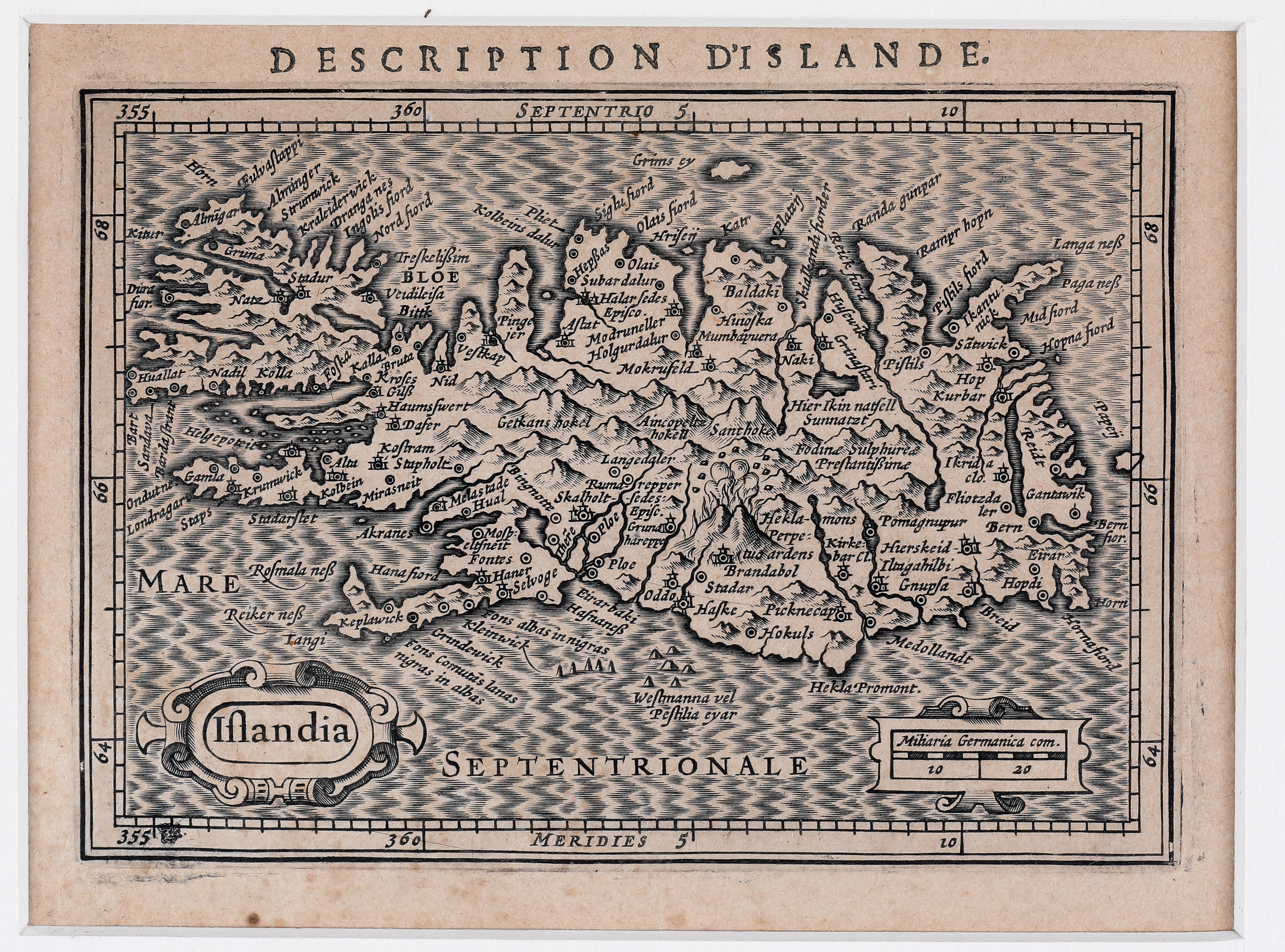
This very rare miniature map is taken from the book „Des Tables Geographiques“, the French edition of „Tabularum Geographicarum contractarum libri“ by Petrus Bertius.
In the bottom left, the title „Islandia“ is enclosed in a decorative strap-work cartouche. The French title „Description d‘Islande“ is to be found on top of the map. A distance scale is placed in the lower right quadrant. In the bottom left corner, next to „355“, the signboard „de wackere Hond“ (the watching dog) is to be seen.
The map depicts many towns, rivers, mountains, lakes and churches, amongst the the bishoprics Skalholt „(„Skalholt Sedes Episc.“) and Holar („Halar Sedes Episco.“).
Even some glaciers are named and the famous volcano is described „Hekla-mons Perpetuo ardens“ which suggests that the volcano was constantly active at the time. Most of the over hundred place-names are from Mercator‘s famous „Islandia“.