
Theunis Jacobsz (1606 – 1650) & Lootsman, Jacob and Casparus (Jasper) (1635 – 1711)
Theunis Jacobsz was the founder of a flourishing publishing house in Amsterdam.
After Jacob Colom (1600 – 1673) he was the second to publish a pilot guide, titled „De Lichtende Columne, ofte Zee-Spiegel, … (1644).
After his early death in 1650 his widow continued the business until their sons Casparus and Jacob could take over. As there was more than one printer of the name Theunisz the brothers applied the noun Lootsman (navigating officer or pilot) to their name to avoid confusion. In 1666 Jacob Lootsman published the first known edition of the „Nieuwe Water-Werelt, Ofte Zee-Atlas“ and the Lootsman family continued marine publishing throughout the rest of the 17th century. This map is from the 1676 edition.
Map details
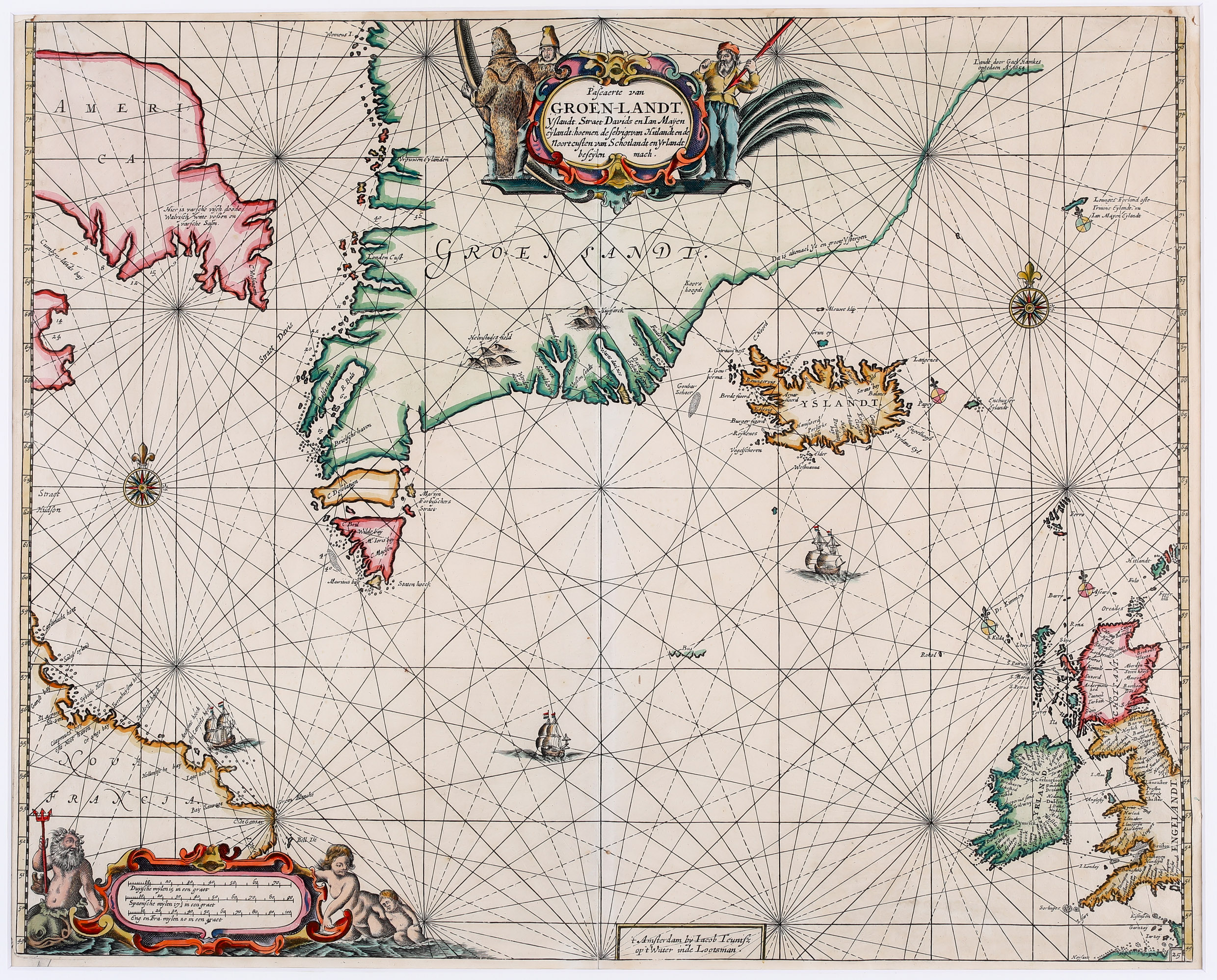
Pascaerte van Groen-Landt, Yslandt, Straet Davids en Ian Mayen eylandt;
hoemen de selvige van Hitlandt en de Noortcusten van Schotlandt en Yrlandt beseyen mach
The beautiful sea-chart of the North Atlantic is decorated in the upper center with a figurative title cartouche which is surrounded by native hunters as well as with compass roses, rhumb lines, sailing vessels and an allegoric ornate distance scale cartouche featuring Neptune and Merfolk in the lower left corner. The map shows Labrador („Nova Francia“), Baffin Island („America“) with the eastern approach to the Northwest Passage, Davis Strait, Greenland, Iceland, Jan Mayen, the Faroe Islands, Ireland and the western part of the British Isles. It includes a detailed plan of coastlines, soundings, cliffs, anchorages, towns and rivers. There are place-names scattered along the coastlines, and inland detail is limited to a few mountains. In Baffin Island (here called „America“) there is a notation that translates: „There is fresh fish, dead whales, while foxes and fresh salmon“. A partial outline continues to the northeast of Greenland with a notation that the area is comprised of ice and large icebergs. Astonishingly the Arctic Circle is omitted.
Along the coastline of Iceland there are some names amongst them „Iokula“ (which probably stands for glacier) but the interior is completely empty. Not even the famous volcano Hekla is depicted.
In the ocean west and east of Iceland the mysterious islands „I. Gouberma“ and „Enchuyser Eyland“ are to be seen.
The „Schulte Collection“ contains three similar sea-charts: Goos of 1669, Lootsman of 1676 and this one, van Keulen of 1681. According to Burden they are derivates of an extremely rare map Johannes Janssonius has published in 1634. The differences between Goos and Lootsman are described in the context of the Goos map and between Goos and van Keulen in the context of the van Keulen map.
Comments by the collector
At the time, there was a strong competition in the map selling market between Jacob Colom, Lootsman, Pieter Goos, Hendrick Doncker and Jacob Robijn but also some kind of cooperation. They supported each other by also selling the atlases of competitors, used their maps to composite atlases under a new authorship and title, to publish „new“ maps by just changing details in maps and so on. This worked quite well until Johannes van Keulen and John Seller emerged as competitors and the defense of the „old guard“ finally collapsed.
The described „business model“ makes it extremely difficult not only for collectors but also for map dealers to identify the author/publisher and the printing/publication year of a specific map with so many similar maps of the same period in the market. Only the publications of a few experts (Koeman, Burden) can give advice.