
Johannes van Keulen (1654 – 1715)
was a Dutch cartographer and publisher who mainly produced nautical charts and atlases. He was the founder of a firm which should become the biggest and most influential name in the history of Dutch sea-charts. Born in Deventer, Johannes established himself in Amsterdam in 1678. In 1680 he gained a patent from the states of Holland and West Friesland for the publication of pilot guides and sea atlases. In that year Johannes released the „Zee-Atlas. De groote nieuwe vermeerderde Zee-Atlas ofte Water-Wereld“ which became immensely popular and was steadily re-produced until 1734. In 1681 „De Nieuwe Lichtende Zee-Fakkel“ (Shining Sea-Torch) appeared. The atlas had charts compiled by Claes Jansz. Vooght and artwork by Jan Luyken. This five-volume work was published in several editions until 1685 and made Johannes van Keulen famous. There were translations of the atlas in French, English, Spanish and Italian language.
Gerard van Keulen (1678 – 1726), the son of Johannes van Keulen, was endowed with talent and by doing an internship with his father, Gerard became a skillful engraver. He was also proficient in mathematics and navigation and established the scientific basis of the van Keulen firm. In 1714 he was appointed hydrographer of the Dutch East India Company and the family remained chart makers until the company’s liquidation.
After Gerard van Keulen’s death at the age of only 49 years, his son Johannes II van Keulen (1704 – 1755) carried on the business. He is in known in particular for his publication in 1753 of a sixth volume of the „Zee-Fakkel“ which contained new charts of the route to the East Indies and was re-printed until 1773.
When Johannes van Keulen the Younger died, his son Gerald Hulst van Keulen (1733 – 1801), great grandson of the founder of the „Empire“, took over the firm. He was responsible for the final true van Keulen editions of the family‘s signature product, the „Zee-Fakkel“. When he died the business was continued by his son Johannes Hulst van Keulen and after his death in 1841 the firm passed out of family hands and flourished under different names until 1885.
Map details
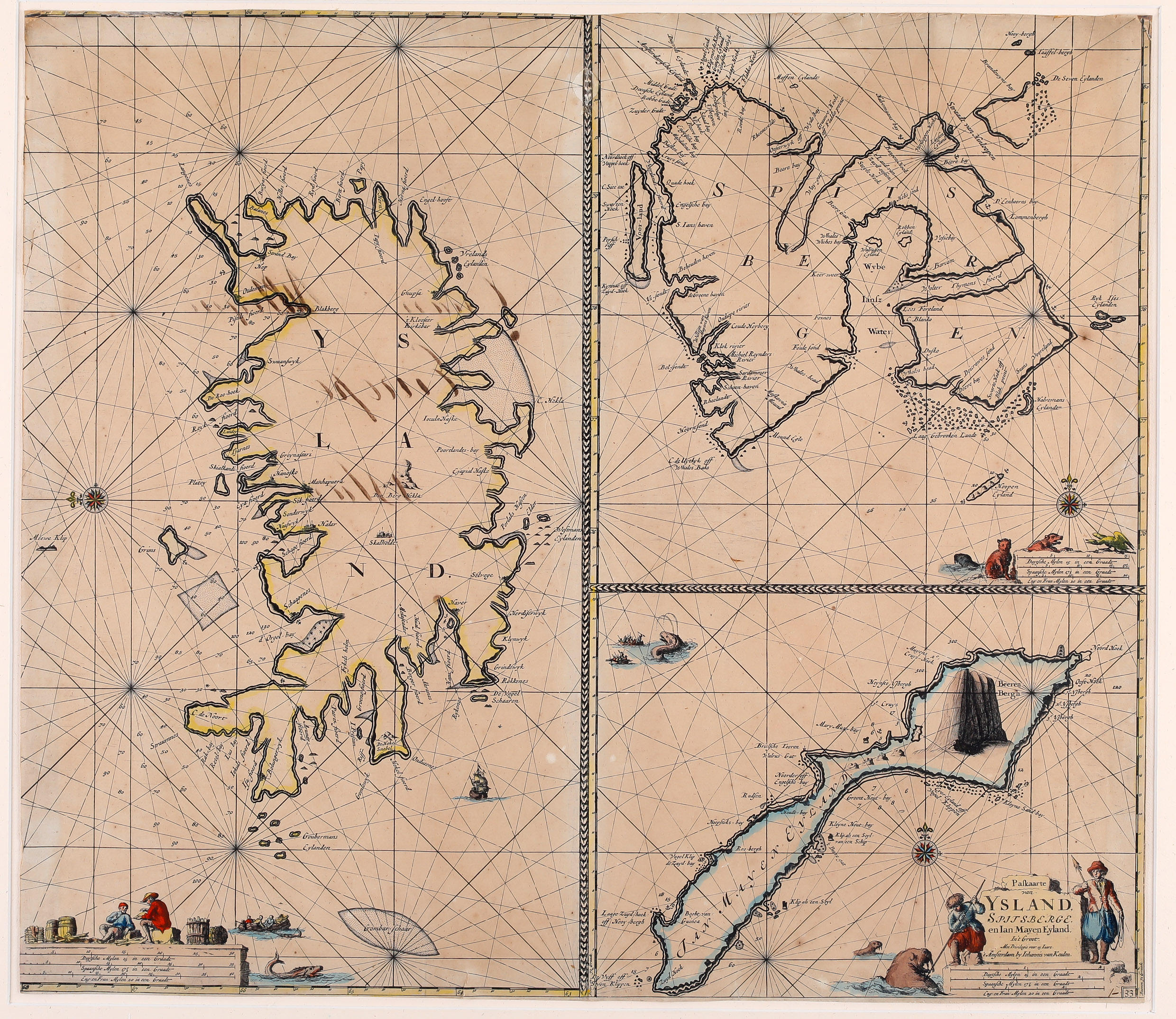
Three charts on one sheet depicting Iceland, Spitsbergen and Jan Mayen, with ornamental borders between the charts, the first sea chart produced by the Van Keulen firm which shows Iceland separately. Before Iceland was just an island „at the edge“.
Each map is adorned by a compass rose, rhumb lines and its own differently decorated distance scales, orienting the maps of Spitsbergen and Jan Mayen to the north and the map of Iceland to the east. The title of the sheet is placed in the lower right corner, underneath Jan Mayen, decorated by two fishermen (one spears a walrus) and mentioning the author.
With regard to Iceland the outline is based on other Dutch nautical charts.
In the lower left corner three fishermen in a boat are rowing in the ocean, accompanied by two sea monsters and just above the distance scales two fishermen are hanging around between barrels and bound driftwood. On the left (North) there are many numbers showing the depth of the ocean. The Western Fjords have turned into two peninsulas, one pointing west and the other north. In the ocean the „Goubersmans Eylanden“ are to be seen which do not exist in reality.
Along the coastline there are quite a few place-names particularly harbours but the interior of the island is nearly empty. Only the bishoprics Skalholt and Holar („Halar“) are labeled. The volcano „Den Berg Hekla“ is to be seen erupting with impressive flames of fire.
Comments by the collector
I bought this map from the heirs of a German collector who had passed away. His maps were offered for sale to members of the „Deutsch-Isländische Gesellschaft“ (German-Icelandic Society). I chose this one though its condition is far from being perfect because of some black stripes (probably ink) in the chart of Iceland. However, I knew that this map is scarce.